Newsletter

Libéria Fort

Libéria Fort. Source : http://regionfrance.com/villefranche-de-conflent/

Libéria Fort was built in 1681 and offers a splendid view of the Têt Valley.

A fortified town at the bottom of a valley Guillem-Ramon, the Count de Cerdagne, built the small fortified town of Villefranche-de-Conflent at the confluence of the Têt and Corneilla Rivers on the road to the Pyrenees in the late 11th century.

In the 12th century, eight corner towers reinforced the town's fortifications, which received a new defensive system in the 14th century during the war between the kingdom of Majorca and Aragon. The 1659 Treaty of the Pyrenees definitively attached Villefranche-de-Conflent and Roussillon to the kingdom of France. The town on the valley floor has preserved its distinguished past in the Conflent capital, an outstanding monumental complex built of pink marble. A superb medieval town lies tucked away behind Villefranche-de-Conflent's ramparts, offering visitors a vaulted sentry walk, 11th-century Romanesque church and approximately 20 house façades listed as historic monuments. The town ramparts are still standing: neo-Classical gates and the bastions that Vauban built around 1680 have joined the medieval curtain walls and towers. In the late 18th century Villefranche-de-Conflent lost its importance, in particular after the provost was moved to Prades in 1773.
A fort built on a mountainside As part of his mission to strengthen the defences of Roussillon, which now formed the kingdom of France's southern borders, Vauban, Louis XIV's chief military architect, stayed in Villefranche-de-Conflent to build a fort intended to protect the area from assaults from Vallespir and Cerdagne. To prevent the bombardment of Villefranche-de-Conflent from Belloch Mountain, in 1681 Vauban had Libéria Fort built atop a 160-meter high spur overlooking the town, offering a splendid view of the Têt Valley. The oblong mountainside fort is made up of three successive walls on three levels in order to hug to the steep slopes. A keep stands in the upper part of the fort, preceded by a moat defended by a reverse fire counterscarp gallery communicating with the main body by two caponiers. The fort has a sentry walk, arrow slits, bartizans (projecting watch turrets), a drawbridge and a main courtyard with a chapel opening out on to it. Under Louis XIV, two accomplices of La Voisin, the poisoner of the court of Versailles, were jailed in the fort's dungeon, called the "ladies' prison". Libéria Fort underwent the trials of war in the late 18th century, surrendering on 3 August 1793 to Spanish troops after the capitulation of Villefranche-de-Conflent. Between 1850 and 1856 Napoleon III decided to strengthen the fort and had the underground passageway built known as the "thousand steps", which connects it to Villefranche-de-Conflent. Visitors can still take this stone-vaulted tunnel with pink marble stairs, but it actually only has 754 steps!
In the surrounding area Three prehistoric caves are open to the public near the village of Villefranche-de-Conflent: Grandes Canalettes, the old Canalettes and the Cova Bastera (prehistoric cave), which Vauban fortified in 1707. The famous little yellow train leaves from Villefranche-de-Conflent railway station and winds its way up through the Pyrenees all the way to the border town of La-Tour-de-Carol.
How to get there Perpignan is 50km away on the N 116. Villefranche-de-Conflent Tourist Office Place de l'Église 66500 Villefranche-de-Conflent Tel. +33 (0)4.68.96.22.96 Fax +33 (0)4.68.96.23.23 & 04.68.96.23.93 E-mail: villefranchedeconflent@voila.fr

> Return to results

Practical information

Address

66500
Villefranche-de-Conflent
Tél. 04.68.96.22.96Fax 04.68.96.23.23 & 04.68.96.23.93

Prices

Plein tarif adultes : 6.00 €, enfants (5 à 11 ans) : 3.50 € Tarifs réduits adultes : 5.00 €, enfants (5 à 11 ans) : 3.00 € Tarifs groupes à partir de 10 personnes : adultes 5.00 €, enfants classe primaire : 3.00 €, enfants classe secondaire : 3.50 €

Weekly opening hours

De juillet à août : 9h à 20h De mai à juin : 10h à 19h Autres périodes : 10h à 18h non-stop

Place Villefranche-de-Conflent

Vue panoramique du village fortifié de Villefranche-de-Conflent. Source : GNU Free Documentation License

An 11th century medieval city, fortified by Vauban in the 17th century, Place Villefranche-de-Conflent is located at the foot of the Canigou in the heart of the Pyrénées Orientales.

Villefranche-de-Conflent is a town founded in 1090 by Count Guillaume Raymond of Cerdagne. It is the capital of the viscounty of Conflent and is situated along a route in the high country of the Pyrenees. In 1117, Conflent and Cerdagne were inherited by the Kings of Aragon.

The town occupied all the available space between the right bank of the River Têt and the foot of the steep slopes stretching down from the Canigou, forming a long plain between two parallel routes. The defensive perimeter was built from the early 13th century. The semi-circular watchtowers date from the 14th century, a testament to the battle between the Majorcan and Aragonese kings over control of Roussillon.

The town was handed over to French control in 1654 during the Franco-Spanish War. The population, hostile to the French, revolted leading to the Miquelet Movement and the Villefranche Conspiracy, in 1674, which revived the war and led Vauban to establish a fortification programme in the region from 1679. He reinforced the former wall along the mountain front. Elsewhere, it was replaced by a curtain wall with four bastions at the corners. This was supplemented by two flat bastions: one towards the Tech river protected the bridge and the other towards the mountain. Unable to build a glacis around the stronghold, Vauban reinforced the bastions. They were fortified and flanked by embrasures for heavy artillery fire. In order to shield sight of the covered way, it was covered with a slate roof. On the right bank, natural caves were converted into casemates.


The fortified town was temporarily reconquered in 1793 during the French Counter-Revolution.


Tourist Information Office

Place de l'Eglise 66500 Villefranche-de-Conflent

Tel: +33 (0)4 68 96 22 96

Fax: +33 (0)4 68 96 07 66

E-mail: otsi-villefranchedeconflent@voila.fr


> Return to results

Practical information

Address

N116 66500
Villefranche-de-Conflent
Tél. 04.68.96.22.96Fax : 04.68.96.07.66

Weekly opening hours

Accessible toute l'année

Fortified town of Collioure

Royal Château of Collioure. Source : http://www.chateaux-francais.fr

Collioure’s château is built on top of ancient Roman buildings, transformed during the Visigothic period.

In 1808, while inspecting the construction of Fort Boyard, Napoleon decided he wanted to complete the defence system protecting Rochefort harbour by erecting a fort on the highest point on Aix, at the furthest tip of the island. Square shaped, this fortified structure measuring over 90 metres on each side is made of brick and entirely fortified. Four galleries run from each corner of the interior courtyard to connect the casemates placed beneath the bastions, each curtain wall holding four casemates whose purpose was to provide shelter for the troops. Protected by a thick embankment covered in a grass glacis, the fort was surmounted by an impressive covered way. 

Due to the immense scale of the site, the restoration work was concentrated on the best-preserved sections but also and above all on the footprint of the “third" fort that would be precisely built in the “exploded” fashion that would spearhead an innovative approach to the organisation of fortified structures. The footprint covers an area of 20 hectares. The structures undergoing restoration house many original objects and items of technical equipment that are being restored one by one, returned to their proper context and explained.


Collioure’s château is built on top of ancient Roman buildings, transformed during the Visigothic period.

Collioure, located on a narrow coastal plain, held a strategic position for the defence of Roussillon and the border transport routes and its port that opens out into the Mediterranean. The Kings of Majorca, who used the fort as their summer residence, created its current layout between 1242 and 1280.


By the late Middle Ages, the château formed an irregular quadrilateral composed of four fronts.


Quizz : Forts et citadelles

> Return to results

Practical information

Address

Place du 8 mai 1945 66190
Collioure
Tel: 04 68 82 15 47Fax: 04 68 82 46 29

Weekly opening hours

Du 1er juin au 30 septembre : 10h00 à 17h15 Du 1er octobre au 31 mai : 09h00 à 16h15

The fortified town of Port-Vendres

Vue panoramique du Port-Vendres. Source : http://nicolasgiraudphoto.eklablog.com/l


An important port due to its position and the depth of its natural harbour.

The site of Port-Vendres has been occupied since the 8th century B.C. Its name comes from a temple dedicated to Venus - Portus Veneris - that in ancient times overlooked the inlet. The first urban settlements were established by the first king of Majorca, James I, in the 13th. The wars against the Aragon kings destroyed the buildings, to the extent that when Roussillon came under Spanish sovereignty in the 15th century, the city had to be completely rebuilt.

After the Treaty of the Pyrenees, the province became part of the kingdom of France once more. King Louis XIV and Vauban, recognising the potential of this port whose deep waters close to Spain made it unique along the Roussillon coast, classified Port-Vendres as a military port.

Budget limits forced French Secretary of State Marquis de Louvois to commission Vauban to carry out a more modest project: the port was slightly modified to allow part of the fleet from the Levant to stay on the Catalan coasts without too much risk. The province’s governor, Maréchal de Mailly, had the old sheltered dock dug out and constructed the Collioure road. De Wailly, the king’s architect, designed the plans. The redoubts built by de Mailly (above Oasis beach, modified during the Second World War to make place for the Lahitolle 1888 9-mm cannons, damaged in 1944 and listed as a historic monument in 1991), by Béar (completed in 1880) and by Fanal (initial construction by Vauban in 1673-1700) protected the access to the new site of Port-Vendres, whose works undertaken by Maréchal de Mailly, governor of the province of Louis XIV, lasted until 1780 and whose monuments were classified as historic monuments in 1933.

In 1838, France first set its sights on North Africa. Plans to extend and improve the infrastructure at Port-Vendres were put into action to make it an important Mediterranean commercial port: a jetty, Place Castellane, Fort Béar and a rail link were built in 1867, and a sea link consisting of liners was set up between the port and Africa in 1885.


The German navy used the French installations in November 1942, then constructed new ones from 1943. The occupation army set up an entrenched camp there enabling it to cope with amphibious operations as well as a land attack from the interior.

The Port-Vendres Stützpunktgruppe was therefore a major component of Germany's control system along the Pyrénées-Orientales coastal front next to Sète and Agde. The town of Port-Vendres was placed under the authority of a port commander led by Korvettenkapitän Kurt Stratmann, then later Fregattenkapitän Walter Denys. The battery in Ullastrel is one of the remnants from this period. On 19 August 1944, the German army retreated. The munitions and arms stores were destroyed, the docks blown up with dynamite to frustrate the Allies progression.


Fort Béar, a military base, erected on the hill between Collioure and Port-Vendres overlooks the town. Originally designed by Vauban, it was modified by Séré-de-Rivières in the 19th century. Converted into a radio compass in 1949, it became a radome in 1960.


Practical information:


Mairie 8 rue Jules Pams 66660 Port-Vendres

Tel.: 04 68 82 01 03

Fax: 04 68 82 19 62

> Return to results

Practical information

Address

66660
Port-Vendres
Tél : 04 68 82 01 03Fax : 04 68 82 19 62

Weekly opening hours

Accessible toute l'année

Fort-les-Bains

Fort-les-Bains. Source : http://lesdanjean.blogspot.fr

This fort was built in 1670 to protect the town of Amélie les Bains.


Fort des Bains is situated at the confluence of the Tech and the Montdony, on the Prats-de-Mollo road. It was built in 1670 by order of the Count of Chamilly to protect the town of Amélie les Bains (formerly Les Bains d'Arles). The plans were drafted by the engineer Saint Hilaire (or Saint Hillaire). Upon his second inspection in Roussillon, Vauban made a few improvements, but did not make the place a strategic element in his system of defense on the Spanish border.

The principles of bastioned fortification on a nearly square plan (one bastion at each corner) were adopted to the land and to the existing structure.


During the revolutionary war between France and Spain, the fort's garrison, which consisted of 440 men under field marshal Michel-Jean-Paul Daudiès (1763-1839), resisted Catalonian troops until their supplies ran out.


In 1888, the fort was the subject of a proposal to defend the Pyrenees, but the project was never followed up.


The building has been a listed historical monument since 18th December 1909.


Town Hall

5, Rue des Thermes 66110 Amélie-les-Bains

Tel.: +33 (0)4 68 39 00 24

Fax: +33 (0)4 68 39 06 46

Courriel : mairie.amelie.les.bains@wanadoo.fr


Tourist Information Office

22 Avenue du Vallespir - BP13 66110 Amélie-les-Bains

Tel.: +33 (0)4 68 39 01 98


Quizz : Forts et citadelles

> Return to results

Practical information

Address

Route de Montalba 66110
Amélie-les-Bains
Tél : 04 68 39 00 24Fax : 04 68 39 06 46 Office du tourisme22 Avenue du Vallespir - BP1366110 Amélie les bainsTél : 04 68 39 01 98

Weekly opening hours

Se renseigner pour l'accessibilité au site

Fort Bellegarde

Le Fort de Bellegarde. Source : ©Doronenko - License Creative Commons - Libre de droit

This fort controlled passage through the Col de Pethus, an easy route through the mountains between France and Spain.

Built in the Pyrénées-orientales, Bellegarde controlled the Col du Perthus passage - formerly known as Portus Pompei (Pompei Passage), which provided an easy route between France and Spain. Owned by the Kings of Majorca, the site was fortified in 1285 to withstand the threat of the neighbouring Kingdom of Aragon. Initially, it consisted of a 20-metre-high watchtower above the Perthus passage, equipped as an autonomous defence unit. The Kings of Aragon reclaimed the region in the 14th century. The tower was then used as a toll by the local lords.

The Treaty of the Pyrenees, in 1659, incorporated the Col de Perthus and the surrounding area into the Kingdom of France, putting the French-Spanish border close to the site. The tour thus acquired strategic importance.

In 1667, the French troops struggled to push back a Spanish attack. The powers that be thus decided to reinforce the border defence system, a decision further backed up in 1674 when, with the works already underway, the Spanish troops captured the fort where they remained until being forced out by the French in 1675. Vauban, during his second inspection trip in April-May 1679, then decided to build a fully-fledged fortress on the site of the tower, for which he approved the plans drawn by his engineer for the fortifications in Rousillon, Rousselot.


The old fort was extended as far as it could be, the old keep was razed, the interior land was flattened, the bastions were protected by small towers that served as redoubts and the star-shaped layout was adopted for the covered way. On completion, the fort had a pentagonal layout.
The main wall was protected by a glacis one kilometre in length and five bastions all linked together. It enclosed a second line of ramparts and the protective walls surrounding the fortress. The fortress, designed to be autonomous, also contained shelter with space for up to 600 men, a chapel, a hospital, a bakery and mill and a big well, six metres wide and 62 metres deep, dug out in 1698. The only access to the fortress was the "Porte de France" gateway, protected by a small halfmoon fort. To build it, Vauban razed the former tower to the ground and lowered the hill by thirty metres. The fortress, which took 30 years to build, covered 14 hectares including 8,000 metres of buildings.

During the French Revolution, the region was the location of fierce battles during the Pyrenees Campaign. In 1793, the Spanish launched an offensive against Roussillon. General Ricardos passed through Vallespir and took Prats-de-Mollo and Fort Lagarde was occupied, which it remained until September 1794 when it was taken back by the troops under General Dugommier after a four-day siege.


Left dormant for over one hundred years, the site was employed by the public authorities after 1939 during the Retirada, when the Spanish Republicans fled Spain to escape Franco's advancing troops. The refugees, whose political opinions were badly perceived, were interned by Daladier’s government. The first camps were set up in Prats-de-Mollo and on the beaches of Argèles, then at the military camp in Joffre and lastly at Fort Bellegarde between January and February 1939.


Town Hall

15 avenue de France 66480 Le Perthus France

Tel: +33 (0)4 68 83 60 15


The fort is open from 3 June to 30 September from 10.30 am to 6.30 pm.

> Return to results

Practical information

Address

66480
Le Perthus
Tel : 04 68 83 60 15

Weekly opening hours

De mai à septembre, ouvert de 10h30 à 18h30 Visites guidées tous les jours à 11h30 , 14h30, et 16h. Hors saison sur rendez-vous.

Salses Castle

Le château de Salses. Source : http://www.leguide66.com/

Château de Salses sits between two natural obstacles, the foothills of the Corbières Mountains and the seaside ponds.

In the Pyrénées Orientales département, the gateway to Catalonia, Château de Salses sits between two natural obstacles: the foothills of the Corbières Mountains and the seaside ponds.

By order of Ferdinand the Catholic, King of Aragon, the fortress was built between 1497 and 1504 by Commander Ramiro Lopez, the King’s Grand Artilleryman, to block France’s access to Roussillon. Given its strategic location on a natural border, it was destined to see combat and came under siege in 1503, before it was even finished. Taken and retaken during the Franco-Spanish campaigns, Château de Salses, along with Roussillon, definitively became part of the Kingdom of France with the Treaty of the Pyrenees in 1659.

As it then lay far from the border, it had less strategic interest and the only reason it was not destroyed was that it would have cost too much. The fortress was later used as an army barracks for transiting troops, then as a storehouse for food and ammunition. Classified as a historical monument in 1886, it was handed over to the Ministry of Culture in 1930, which restored it and opened it to the public.


Château de Salses has many of the attributes of a medieval castle. It has kept the round stone towers at the ends of the long, continuous curtain walls, and has a keep to hold the fortress’s vital reserves: the arsenal and food stocks. And yet, notably after the adjustments made after the first siege in 1503, it should be considered as a transitional building, the forerunner of the bastion.

At the end of the 15th century, the development of metal cannonballs required changes to the military fortification. Indeed, the medieval castle, which could resist fragile stone cannonballs, became vulnerable with the appearance of cast iron cannonballs.

Château de Salses illustrates the architectural solutions developed to deal with the devastating effects of metal cannonballs. To avoid enemy fire as much as possible, the fortification’s defences are deeply embedded in the ground, sheltered deep in the ditch. To the southwest and northwest of the fortress, two promontories set in front of the circular constructions seek to keep the enemy at a distance by eliminating blind spots: they were the precursors to the geometrical shapes of modern bastions. Attacks on the fortress itself are delayed by the external works; the curtain walls are no longer crenellated and now have cannon embrasures. Characterised by its thick walls, wide moats, imposing external works, artillery installations on wide platforms, Château de Salses illustrates the necessary adaptation of military architecture to developments in the art of warfare.


Salses Fortress

66600 SALSES-LE-CHÂTEAU.

tel.: +33 (0)4 68 38 60 13.

fax: +33 (0)4 68 38 69 85.
 

Open: from 1 June to 30 September, from 9 am to 7 pm. From 1 October to 31 May, from 10 am to 12.15 pm and from 2 pm to 5 pm.


Closed on 1 January, 1 May, 1 November, 11 November and 25 December.

Permanent exhibition. Free visits of the exterior. Guided tours of the fortress.

Access from Béziers: on the A9 motorway toward Perpignan, take exit No. 40, then the D 627 and N 9 roads toward Perpignan. From Perpignan: take the N 9 toward Narbonne.
 

Partially accessible to disabled visitors.
 

> Return to results

Practical information

Address

66600
Salses-le-Château
tél. 04 68 38 60 13.Fax. 04 68 38 69 85.

Weekly opening hours

Du 1er juin au 30 septembre de 9h à 19 h. Du 1er octobre au 31 mai de 10h à 12h15 et de 14h à 17h. Visites libres des extérieurs. Visites commentées de la forteresse.

Fermetures annuelles

Fermé les 1er janvier, 1er mai, 1er novembre, 11 novembre et 25 décembre.

The fortified town of Binche

The fortified town of Binche. Photo of the town of Binche.

The fortified town of Binche, dubbed the 'Carcassonne’ of Wallonia.

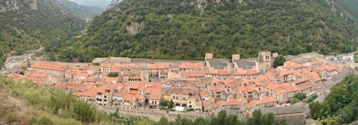
With its stone wall surmounting an immense earthen embankment stretching 2.5 kilometres and its 25 towers, Binche boasts a monumental ensemble unique in Belgium. In fact, it is the only medieval surrounding wall that has been almost entirely preserved in the whole country. It is no exaggeration to call it the Carcassonne of Wallonia! Only the gates, five towers and some three hundred metres of wall sections have disappeared over the years. The site represents over three centuries of military architecture.

Originally, Binche was a simple dependency in the parish of Waudrez, the Roman site of Vodgoriacum. Founded in the 12th century, the town was awarded the status of new town in 1120. Instead of a keep, the Count of Hainaut surrounded the residential districts set in the far south of a spur encircled by the small river Samme (also called the Princess) with a stone wall. The town of Binche already participated in the county's defence from the 12th century. This was supported as much by strongholds owned by the count and managed by a feudal lord (in Binche, he is mentioned as far back as 1138) as well as châteaux belonging to vassals. The network of fortresses formed a strategic chessboard. An agricultural centre, the town quickly became a thriving producer of woolen fabric. A deanship was also established there.

A first stone wall was erected in the 12th century to block the rather wide access via the spur. This example seems early for the Lotharingian principalities where earth and wood were still the preferred materials for urban walls. There are only a few remaining traces near the château and the Posty rampart. The north front has completely disappeared. The historians place it at the top of Rue de la Gaité.

From the first findings of the digs conducted since 1996 in the château grounds by Wallonia’s archaeological department, the count had built in the 12th century a vast fortified palace of which the ruins of the hall, the lecture hall and the chapel were unearthed at the far south of the spur. The fortifications were built over a long period and adapted systematically to the advances made in defensive architecture and armaments: from the late 14th century, new architectural forms acknoweldged power-fired artillery, which was used in the West from around 1320.

In Binche, there is no indication that the large surrounding wall built from the 14th century was initially adapted to this new type of weaponry. The new towers were very prominent and equipped with an intermediate level of defence. The value of the new walls came from the way they were constructed, their foundation laid on archways, which provides stability and saves on materials, seeing as how the subsoil, with the exception of the south section, was unstable and marshy in parts.  This system was practised in many other towns in the former Netherlands (Lille, Valenciennes, Brussels, Bruges, Namur, etc.).


In the late 14th century, the master builders for the Count of Hainaut, Thomas Ladart, born in Ath, and Noël Camp from Avaine, led a campaign to modernise the surrounding wall. New towers, inhabitable and fitted with openings (windows and arrowslits) were added to the wall. In the early 15th century, in Hainaut, which was neutral but caught between Burdundy, France and Liège, it became important to arm and reinforce the garrison and the ramparts. Binche acted as a hub, as it did, for example, during the operations against the principality of Liège from 1406 to 1408.

Later, once under Burgundy control, Binche was one fortress among others. Gunboats were installed in the curtain walls of the old cemetery. The small tower was built there and equipped with gunboats for artillery fire. Until the mid-16th century, despite the progress made with artillery and fortifications, Binche was part of the defensive strategy of Hainaut and the Netherlands, at least as a centre for the assembling of the imperial troops, as testified by two sieges, in 1543 and 1554. However, the siege of 1578 rendered the urban defences definitively obsolete, commanded as they were from the neighbouring heights.

From the old Brunehaut road leading to Maubeuge, you can see the top of the belltower of the collegiate church, the rest of the town being hidden by the drop in terrain. Numerous cannonball strikes had been hastily patched over in the southern section: areas filled with brick and the addition of decorative architectural features (pink sandstone in the ramparts and gothic vaults) are still visible.

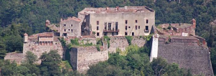
The sumptuous Renaissance palace built by the Mont-de-Marsan architect Jacques Du Broeucq for the regent Mary of Hungary, on the foundations of the medieval castle, was a magnificent target for the French cannons. Burned down in 1553, it was permanently reduce to ruins in 1578. Under Archdukes Albert and Isabella (1599-1621) a restoration was attempted but failed to reach completion. A number of sculpted pieces were sent to Mons (such as the entrance gate) or were reused in Binche itself.

In the 17th century, Binche served occasionally as a logistics unit or a parade ground for marching armies. Beforehand, the town was seized twice by the French: in two days during 1643, then by Turenne in 1654. In 1668, it was ceded to France for ten years. During the campaign of 1672-1674 led by Louis XIV, it served as a post for the army of the field. While fortifications were built during this time, by the early 18th century, the surrounding wall was unusable: there were breaches in the curtain walls and the towers were razed to the ground. This all put an end to Binche’s military role. The border was pushed north but the defence of the region was provided by the Toumai-Mons-Charleroi line.

In the 19th century, the town lost its fortified gates and the wall was little by little enclosed by individual properties. In 1995, a vast restoration campaign was started in Binche and digs were conducted with the help of the European Community and the Region of Wallonia, as part of the Objectif 1 programme. These far-reaching works led by Wallonia's archaeological department between 1995 and 1999, precisely revealed the evolution of the ramparts and the chateaux in the town.


Binche Tourist Information Office

Grand-Place
7130 Binche

Tel.: 064/33.67.27

Fax: 064/23.06.4


tourisme@binche.be

> Return to results

Practical information

Address

7130
Binche

Weekly opening hours

Accessibilité toute l'année

Détail territoire Nord

Porh Punz Battery Gavres

Le fort de Porh-Puns (le port du puits, en breton). Source : Ouest-france

Located at the mouth of Lorient harbour, Gâvres Peninsula is home to several coastal batteries designed to protect the citadel of Port-Louis and, during World War II, Lorient harbour and its submarine base.

Port-Puce

The first fort built at Gâvres, in 1695, was Port-Puce (or Porh Punz in Breton), by decision of the Marquis de Lavardin, to protect Port-Louis. Very quickly it was equipped with 10 cannons and 2 mortars. At the end of the 18th century, it was equipped with a guardhouse housing 60 men. It underwent major changes a few years later with the addition of land and the construction of an ammunition magazine.


World War II

At the start of World War II, Gavres Peninsula had two batteries along with the fort. The Germans, notably Organisation Todt, added 4 casemates, a fire stand and personnel shelters, making the peninsula a powerful weapon against Allied aircraft and ships, both night and day.

The 4 casemates on the municipal campground can still be visited today. The fort is not open to the public, but it is an impressive sight when the sea is rough.

> Return to results

Practical information

Address

Porh-Puns 56680
Gavres
+33 (0)2.97.82.46.55

Weekly opening hours

open to the public every week-end