Newsletter

The Chuise de Bauma Negra

View of the Chuise; Source : fortification.pagesperso-orange.fr

The Chuise de Bauma Negra belongs to the system for controlling the gorges that lead to Nice within Séré de Rivières' system.

The Chuise de Bauma Negra belongs to the system for controlling the gorges that lead to Nice within Séré de Rivières' system. The fortification was constructed between 1884 and 1887 to block the way to Nice from la Tinée. The Chuise is situated at the narrowest point of the valley, in the Mescla gorges, just before the confluence with the Var. Its design is identical to that of the Chuise de Saint-Jean-de-la-rivière. It is a fort built into a dam.

The limestone valley of La Roya is a communications route that has been controlled in turn by the Sardinians, the Spanish, the Austrians and the French. The southern part was incorporated into France in 1860 during the reintegration of the county of Nice. Control of this border region allowed the regulation of Italian activity. In this respect, the fort provided support for the Fort du Pic Charvet. It is built on the right bank of the gorge, on the edge of the road. It combines concrete parts with a two-storey façade in stone cut into the cliff. The structure comprises two equipped floors next to the road. It has openings for 40 and 120 mm canons. Underground galleries lead to the gun shelters and firing posts that in turn lead on to the main road. Two rolling bridges, which could be moved from inside the fort, allowed the road to be cut off. It could house between 30 and 60 men. There was no separation between the stores and billets. On the left bank of the gorge, the engineer had planned to install mortars to catch the enemy in crossfire. The fort is not open to the public.
Belvédère Tourist information office: + 33 (0) 4 93 03 41 23 Saint-Martin de la Vésubie Tourist centre: + 33 (0) 4 93 21 28

> Return to results

Practical information

Address

6450
Utelle
04 93 03 21 28

Weekly opening hours

Le fort ne se visite pas

La Chuise de Saint-Jean La Rivière

View of the Fort de la Chuise de Saint-Jean-la-Rivière. Source : sud-passion


The Chuise de Saint-Jean-la-Rivière is part of the system controlling the gorges that lead to Nice in the Seré de Rivières system.


The Chuise de Saint-Jean-la-Rivière is part of the system controlling the gorges that lead to Nice in the Seré de Rivières system. A combination of stone and concrete, this Chuise is a cave-fort dug out of the cliff. It is a small building cut out of the cliff in the Gorges de la Vésubie between Saint-Jean-la-Rivière and Le Suquet. Like the Chuise de Bauma Negra, it is part of the system controlling the gorges in the Nice hinterlands. These are barrier forts.


The Valley of the Vésubie, called the Switzerland of Nice, is the shortest (48 km) valley in the Nice hinterlands. The lower valley, starting at Saint-Jean-la-Rivière, makes its way through the gorges of the Alpine foothills before joining the left bank of the Var River through the Défilé de Chaudan. The Ligures used this passage and it was a busy route in the Middle Ages, as it is one of the main salt roads leading to Piedmont via the Col de Fenestre. In the 16th century the Valley of La Roya became the preferred route. Two hundred years later, the region opposed the English, Sardinians and Austrians during the War of the Austrian Succession. During the French Revolution, the region gave shelter to those who refused military service, the “barbets”, who carried out guerrilla actions against the regular troops.


In 1860, the County of Nice and Savoy became part of France, bringing the Italian threat closer just after France had been defeated by the Prussians and Italy had been unified by the King of Piedmont. The failure of the system of defences, which was unable to protect cities from enemy fire, led Seré de Rivières to develop a new system based on the principle of forward defence lines protecting a central core. Fortifications were set up near the border, making use of natural obstacles to monitor, control and block the passages, with their layout determined by area covered by each one’s fire.


The building comprises two floors on the side of the road. It is equipped with 40 and 80-mm cannon openings. The underground galleries lead to shelters and firing positions that cover the length of the national highway. Two movable bridges that can be manoeuvred from inside the fort were used to cut off the road. It can house 30 to 60 men.


The fort cannot be visited.


Syndicat d'initiative de Belvédère: +33 (0)4.93.03.41.23

Saint-Martin de la Vésubie Tourism Office: +33 (0)4.93.21.28


Fortweb website on European fortifications


> Return to results

Practical information

Address

6450
Saint-Jean-La-Riviere
04 93 03 21 28

Weekly opening hours

Le fort ne se visite pas

Fort de la Forca

The fort de la Forca. Source : sud passion

Constructed between 1887 and 1890, it operated in conjunction with the fort des Mille Fourches, which is a copy of it. The Redoubt of les Trois Communes, built later, protects them both.

Constructed between 1887 and 1890, it operated in conjunction with the fort des Mille Fourches, which is a copy of it. The Redoubt of les Trois Communes, built later, protects them both. Its construction was brought about as a result of the Treaty of Turin of 1860. The Savoie and Nice had become part of France once more. The Valley of the Roya, a communications route running north to south in the heart of the Alpine mountain range, was shared between France and Italy. Sealing off the new border had thus become a strategic matter of utmost importance. This small fort was in response to the increase in power of the house of Piedmont, which was gradually uniting Italy under its strict control with Italy's entry into the Triple Alliance and its policy of fortifying the Tende mountain pass.

Le fort de la Forca belongs to the first generation of the Séré de Rivières system. A belt of forts, built upon natural obstacles at a distance of a few kilometres, provided a range of artillery cover to protect a town (or central nucleus) from 6 kilometres to the rear from enemy bombardment. La Forca is a small fort with a façade with very few openings. It is surrounded by a moat and flanked by concrete caponniers. The internal courtyard was replaced by a vaulted chamber. The redoubt of les Trois Communes, built later, protected them. It reflected the rise in tensions between France and Italy and technological developments in particular, such as the "torpedo shell crisis", which rendered some of the Séré de Rivières system obsolete. New projectiles came in the form of cylindrical warheads, which exploded in the open air, with steel replacing cast iron; the new mixes of explosives were more powerful and no longer created smoke; canons (Bange 155 mm and 220 mm) could fire further. Armour plating and surface stonework could therefore be pierced and obstacles on the ground (moats and parapets, caponniers etc.) shattered.
Belvédère Tourist Information office: + 33 (0) 4 93 03 41 23 Saint-Martin de la Vésubie Tourist centre: + 33 (0) 4 93 03 21 28 Access The D 2566 via the Turini pass, towards the resort of Camp d'argent and then Authion. Car park in les Trois Communes On foot from les Trois Communes car park

> Return to results

Practical information

Address

6540
Saorge
04 93 03 21 28

Château Queyras

Château Queyras. Photo : Vclausse

For centuries the Ubaye has been a border area with several fortifications redeveloped by Vauban, amongst which is the one at Le Queyras.

Ever since the 16th century, the glacial rock bar that blocks the Le Guil valley has been the site of a castle designed to provide cover for the side of Le Queyras that faces downriver. It would appear that the first castle constructed there dates back to the 11th century. Its role was to protect the valley from looters arriving from Provence.

Positioned at an altitude of 1,400 m, the construction looks over the Le Guil valley. Château-Queyras served as an outpost designed to stall the enemy and give the towns of Montdauphin and Briançon the time required to prepare their defences.
In 1692 the fort resisted an attack from the people of the Savoie, at which time Vauban decided to reinforce it. He recommended an enlargement and modernisation programme. He created an advanced redoubt on the northern side and also planned an extension to the fort in the western part. In 1700, he planned the construction of a new compound on the eastern side and the work was carried out in the 18th and 19th centuries.
He ordered the destruction of some of the buildings considered to be out of keeping with his plans as the narrowness of the premises prevented the accommodation of an expanded garrison to control the region. This monument combines the 14th century towers and square dungeon with a Vauban-style structure: a bastioned envelope, parapets with slits for firing and demi-lune entrance. The curtain has retained its watch turrets. Batteries were constructed downriver in the 18th century.
Mairie 05250 Château-Ville-Vieille Tel: + 33 (0) 4 92 46 86 89 Fax: + 33 (0) 4 92 46 82 00

> Return to results

Practical information

Address

5350
Château-Ville-Vieille
04 92 46 86 89

Weekly opening hours

Mars à novembre

Fort du Mont-Ours

View of the Fort du Mont-Ours. Source : sud passion

Occupying a strategic position, the site of Mont-Ours was included in the "Seré de Rivière" system for controlling the Italian border and then in the Alps Maginot Line.

This small fort was constructed rather belatedly in 1898, to complete Seré de Rivières' "second generation" system. It controlled access to the Col des Banquettes between the Fort du Mont-Agel and the Fort du Barbonnet. It served as their lookout post. Its construction came about during a period of intense Franco-Italian confrontation, marked by Italy's entry into the Triple Alliance in 1882 and the tariff war of 1888-1898.

The small Fort du Mont-Ours belongs to a group of covering fortifications. The defensive organisation in effect consisted of a "holding" or "damning" fortification designed to save on armed forces: it was more powerful and also staggered across the terrain, with two sub-groups of covering fortifications. The first type consisted of blockhouses, high altitude army camps and batteries that could be manned quickly and hold out until reinforcements arrived, whilst the second comprised of blockhouses positioned on the main access routes and provided the link between the forts of the first group.
The construction of this relay building was as a result of a development in military tools. The first factor was technical and saw the improvement in armaments and the manufacture of a more powerful shell with a delayed detonation known as the "torpedo shell", which rendered obsolete Seré de Rivières' heavy defensive system (moats, open air structures etc.). The second was related to the dissolution, in 1888, of the Defence Committee established by Adolphe Thiers. This was succeeded by the Upper War Council, which was more politically involved and decided to limit the allotted funding. Most of the forts on the south east of the line thus remained built in stone, with concrete being used as a priority on the structures on the northern part of the line, which were geographically and militarily more exposed, especially in 1902 when France signed an agreement to neutralise potential Italian aggression. The military leaders preferred to increase the number of relay stations, high altitude stores and forces along the border. That is why the Army of the Alps was set up from 1887 onwards. It would gradually come to permanently occupy the military sites.
The fort consists of a single main building with two floors, with a surrounding wall that overhangs its immediate edges. Below there is a collection of walls sloping beneath a platform designed to support light artillery. A track leads to one of the blockhouses of the Maginot line. The site is currently occupied by the fire service.
The period between the wars was only to strengthen these strategic positions in the face of Mussolini's irredentism. In 1925, General Degoutte, the appointed commander of the Army of the Alps, drew the Upper War Council's attention to this threat. A Committee for the Defence of the Borders was formed. It was presided over by General Guillaumat. The first works on the southeastern Maginot line of the "redoubt programme for the defence of Nice" were started in 1927 under the impetus of General Degoutte. In 1930, funding for the construction of the Maginot line was approved and the execution of the work was assigned to the Committee for Organising the Fortified Regions (Commission d'Organisation des Régions Fortifiées or CORF).
The Committee for the Defence of the Borders suggested 75 forts of several types: "Sturdy" well armed and well equipped structures; intermediary forts of the main line of defence, whose armaments complement the former; artillery forts and, behind the line, "shelters" (3 types) where troops would be accommodated between battles. In April 1934, fortress troops, battalions of detached alpine fortress infantry regiments and alpine fortress battalions were set up. These troops were complemented by artillery and specialist units.
In 1937, in order to contain the Italian threat, the Caval plan hastened the reinforcement of the most exposed zones. In 1939, France could rely on an (incomplete) system of two lines of defence, consisting of 36 casemates in the southeast. The second fort at Mont-Ours is a result of this initiative. Like all the large forts in the area, the blockhouse was equipped with 81 mm and 75 mm mortars. Priority was given to underground transmissions, both radio and optical. Supplies and munitions arrived in small trucks.
Useful information Sospel Tourist centre: + 33 (0) 4 93 04 15 80 / + 33 (0) 6 85 96 72 88 Edelweiss Association Access By car via the col de Segra and the col des Banquettes Pedestrian access to the platform from the col du Castillon

Colmars-les-Alpes

Vue panoramique sur Colmars-les-Alpes. Au premier plan le Fort de France. Source : ©Olivier JOSEPH - GNU Free Documentation License

The site of Colmars-les-Alpes, a rocky outcrop in the Ubaye valley, is one of the interesting legacies of Vauban's task of fortifying the borders.

Colmars-les-Alpes is a mountain village in the Alps of Haute Provence, located in the high valley of the Verdon between the Col d'Allos and Saint André les Alpes and controls the border with the Savoie river Ubaye via the Col d'Allos. Its military history bears witness to its strategic position: the village is surrounded by ramparts and guarded by two forts. At the end of the 14th Century, Colmars-les-Alpes was in fact a border town with the territory of the Duke of the Savoie, who was in alliance with the Spanish. Its situation on an outcrop in the valley forced the people and the authorities to modify and complete their defensive system. In the 17th Century Colmars-les-Alpes was provided with the system of well-developed fortifications that gives it its current appearance. The system, conceived from the recommendations of Vauban, who never went to the town, demonstrates the adaptability of the architect's plans to suit existing structures and the terrain.

The collection of fortifications comprises the town and a large walled enclosure marked by monumental gates, supported by the Fort de France and the Fort de Savoie. This plan was suggested by Niquet, who was director of fortifications for Provence. Initially, the town was enclosed by fortified towers, which Vauban considered to be too weak. He therefore suggested flanking the square with two forts. These structures were built by Richerand.
Downstream, from the side of the entrance to the town, Fort Calvaire or the Fort de France was built to a square plan.
Upstream, Fort Saint-Martin or the Fort de Savoie was built, which was trapezoid in shape. It was flanked by a tower whose lines were criticised by Vauban - his recommendations were not followed. The Fort de Savoie, perched on a hill to the north of Colmars-les-Alpes, was built from 1793 onwards. The building was a contemporary of the citadel at Entrevaux. It was supposed to contain any invasion from the Savoie. It could house up to 150 men.
Access is via the D 908 which links Saint André les Alpes to Barcelonnette The fort de Savoie is open in July and August Guided tours every day at 10 am Tourist Information Office: + 33 (0) 4.92.83.41.92 The Fort de France is not open to the public

> Return to results

Practical information

Address

4370
Colmars
04 92 83 41 92

Weekly opening hours

Juillet-août: visite guidée à 10h

Fort des Mille-Fourches

Detail of the two caponniers of the Fort des Mille-Fourches. Source Fortweb.net

The fort des Mille-Fourches was constructed between 1887 and 1890. It operated in conjunction with the fort de la Forca, of which it is a copy. The Redoubt of les Trois Communes, built later, protects them both.

The fort des Mille-Fourches was constructed between 1887 and 1890. It operated in conjunction with the fort de la Forca, of which it is a copy. The Redoubt of les Trois Communes, built later, protects them both.

Its construction was brought about as a result of the Treaty of Turin of 1860. The Savoie and Nice had become part of France once more. The Valley of the Roya, a communications route running north to south in the heart of the Alpine mountain range, was shared between France and Italy. Sealing off the new border had thus become a strategic matter of utmost importance. The military defeat of 1870 forced the complete reorganisation of national defences: reforms within the system of command, the general staff and the armed services and the redefining of the military constituencies into eighteen military regions. All these initiatives were designed to help in preparing to reverse territorial losses and avenge the insult of losing the Alsace-Lorraine. The northeastern border was the subject of all the attention. However, General Seré de Rivières was aware of developments in Franco-Italian relations.
The redoubt of les Trois Communes, built later, protected them. It reflected the rise in tensions between France and Italy and technological developments in particular, such as the "torpedo shell crisis", which rendered some of the Séré de Rivières system obsolete. New projectiles came in the form of cylindrical warheads, which exploded in the open air, with steel replacing cast iron; the new mixes of explosives were more powerful and no longer created smoke; canons (Bange 155 mm and 220 mm) could fire further. Armour plating and surface stonework could therefore be pierced and obstacles on the ground (moats and parapets, caponniers etc.) shattered. The fort des Mille-Fourches belongs to the first generation of the Séré de Rivières system. A belt of forts, built upon natural obstacles at a distance of a few kilometres, provided a range of artillery cover to protect a town (or central nucleus) from 6 kilometres to the rear from enemy bombardment. Le Mille-Fourches is a small fort with a façade with very few openings. It is surrounded by a moat and flanked by concrete caponniers. The internal courtyard was replaced by a vaulted chamber.
With Mussolini's rise to power and the deterioration of Franco-Italian relations, the Authion became a fortified mountain range. The construction in 1929 of a cable car linking the road from Moulinet to Turini and the camp at Cabanes Vieilles made it easier to get supplies to troops all year round. As part of Maginot's programme, the forts of Plan Caval, Raus, la Béole and la Déa were under construction from 1933 onwards. The group was part of the fortified section of the Alpes-Maritimes département (secteur fortifié des Alpes-Maritimes or S.F.A.M.). On the 10th June 1940, Italy declared war on France (Mussolini was hoping to annex Nice and the Savoie). The Italian offensive took place from the 20th to the 25th June. On the 25th June, the armistice was signed. The Alpes-Maritimes was part of the free zone, with the exception of Menton and part of the towns of Isola and Fontan.
In 1942, following the allied landings in North Africa, the Alpes-Maritimes was occupied by the Italians. They were replaced by the Germans in 1943. After the allied landings of the 15th August 1944 at Dramont in the Var, most of the département was liberated on the 6th September, although the high valley of la Roya and the Authion mountain range were still occupied by the Germans who rebuilt the fortifications. General de Gaulle wanted Tende and La Brigue to become part of France again. He hoped to force the hands of the Allies who were quite hostile to any changes to the borders. So, in Nice on the 9th April 1945, he announced the offensive on the Authion and la Roya. Operation "Canard" (Duck) began on the 10th April. On the 12th April, the French took the Authion. French sovereignty over these former Italian territories was recognised by the Treaty of Paris.
Belvédère Tourist Information office: + 33 (0) 4 93 03 41 23 Saint-Martin de la Vésubie Tourist centre: + 33 (0) 4 93 03 21 28 Access The D 2566 via the Turini pass, towards the resort of Camp d'argent and then Authion. Car park in les Trois Communes On foot from les Trois Communes car park

> Return to results

Practical information

Address

6540
Saorge
04 93 03 21 28

Redoubt of 3 Communes

First fort in the Alps to be built of reinforced concrete, Redoubt of 3 Communes is part of the system for securing the countryside around Nice developed by Seré de Rivières.

The first fort in the Alps to be built of reinforced concrete, the Redoubt of Les Trois Communes is part of the system for securing the countryside around Nice developed by Seré de Rivières. Constructed in 1897 on the site of a former Sardinian battery, the Redoubt of Les Trois Communes occupies one of the Authion's strategic positions and controls the La Roya and Vésubie valley. It watches over the crest of the Ortiguié which leads to the Raus pass and the former border. It is the highest point in the Authion range at an altitude of 2080 metres.

The limestone valley of La Roya marks the easternmost edge of the Nice hinterland. Belonging first of all to Provence in the 13th century and then to the Savoie at the end of the 14th century, it is a transit zone for goods from the coast towards Piedmont. Controlled in turn by the Sardinians, Spanish, Austrians and French, in the 18th century it was the setting for many confrontations, most notably around Sospel, between Sardinian anti-revolutionary troops and republicans. The lower valley of La Roya became French during the reattachment of the county of Nice to France in 1860. The upper valley was retained by Italy, giving more weight to the strategic role of the forts. The aim of the redoubt was to protect two other forts built on the Authion: Forca and Mille Fourches. It thus played its part in securing the valley.
Small in size, built on high ground and surrounded by a moat, the fort was one of the first to be built from reinforced concrete at the end of the 19th century and the first fort in the Alpes-Maritimes to use both stone work and reinforced concrete. It was thus a "prototype" that demonstrates the development of fortification techniques. It is of note that, to save money, only the sides exposed to Italian fire were reinforced with concrete. During the construction of the Alps Maginot line, protection was provided by Fort Saint-Roch. Violent battles took place there in 1945. Preserved as it was, the fort bears witness to the violence of the fighting of April 1945 that allowed the 1st DFL to take back the Authion range from the Germans.
Tours from June to October Belvédère Tourist Information Office: +33 (0) 4 93 03 41 23 Saint-Martin de la Vésubie Tourist centre: +33 (0) 4 93 03 21 28 Access Via the col de Turini on the D 2566, towards the resort of Camp d'argent and then Authion. Car park in Les Trois Communes

> Return to results

Practical information

Address

6540
Saorge
04 93 03 21 28

Weekly opening hours

Le fort ne se visite pas

Arc de Triomphe

Arc de Triomphe. Photos © Frédéric Prochasson - Fotolia.com

There are as many different viewpoints of the Arc de Triomphe, than there are roads starting from Place Etoile...

Short history of the construction In February 1806, Napoleon I orders the construction of the Arc de Triomphe, in order to commemorate the victories of his armies. Finally the emperor decides to built it in Place de l'Etoile. The first stone of the monument is placed on August 15th 1806. The plans of this construction are those of the architect CHALGRIN. In 1870, in occasion to Napoleon's wedding with the archduchess Marie-Louise of Austria, he will built a trompe-oeuil of wood and painted material. Finished in time for the ceremony, the decoration gives an idea of what the monument will be once completed. CHALGRIN dies in 1810. He is replaced by Louis-Robert GOUST. At the end of the year 1813, the Arc reaches 19 meters height. The events of 1814 questions everything. Under the "Restoration", the works doze. Louis Philippe, who became king in 1830, decides to give life to this project again. The works start again and the Arc de Triomphe, dedicated to the Armies of the Revolution and to the Empire will be completed by the architect Guillaume - Abel BLOUET. The monument will be inaugurated on July 29th 1836.

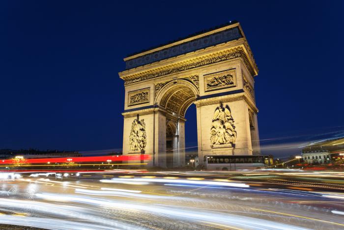
The Monument The proportion of the Arc de Triomphe are enormous : it measures 49 meters height and exceeds 45 meters width. The arch of the two frontages reaches 20,50 meters of height for a width of 14,50 meters. The transversal frontages are pierced of an arch of 19 meters height on a width of 8,50 meters. The big frieze surrounding the four façades represents the great personalities of the Revolution and the Empire, or furthermore the return of the armies from Italy and Egypt.
The most imposing ornament is without any doubt the one formed by the four colossal groups erected on each pier of the two great façades : - Avenue de Champs Elysées : the Departure of the volunteers (left), still called La Marseillaise, of François RUDE and on the Triumph of the emperor (left) sculpted by Jean-Pierre CORTOT - Avenue de la Grande Armée, the two sculptured alto-rilievo represent the Resistance on the right, and the Peace on the left. On the interior surfaces of the big and small arches, the names of the generals and the great battles of the Revolution and the Empire are engraved. On the ground, near the grave of the unknown soldier, several bronze plaques commemorate important events of the contemporary history : the proclamation of the Republic on September 4th 1870, the return of Alsace-Lorraine to France on November 11th 1918 the call to arms on June 18th 1940. It also evocates the memory to the fighters and the resistant fighters of the Second World war, as well as the memory of "the dead for France" in Algeria, Tunisia and Morocco.
Climbing up the Arc de Triomphe Climbing up the Arc de Triomphe means climbing up 284 steps (an elevator gives access to handicapped persons), but it also means to have access to different museum halls and to the terrace. The big hall of the museum, situated under the terrace, exhibits a vast number of documents : engravings, drawings, photographs, models and various original parts of projects (for example the elephant), the construction and the decoration of the Arch, as well as great events, for example the return of Napoleon's I ashes (the 15th of December 1840),Victor HUGO's dead guard (May 29th 1885), the march of the Victory (on July 14th 1919), the arrival of the unknown soldier (January 28th 1921), the homage to General de Gaulle on the grave of the unknown soldier in a released capital (August 26th 1944). The terrace allows/gives a splendid view of Paris, the Champs Elysées, the Louvre, the Eiffel tower, the Dome des Invalides, and westwards the Arche de la Défense.
The Unknown Soldier The armistice, which puts an end to the First World war, is signed on November 11th 1918 in Rethondes (near Compiègne in Oise). Nevertheless the joy of the victory is plunged into mourning of 1 500 000 victims, for the majority very young. Soon in the small villages as well as in the big cities, monuments in memory of all the dead will be raised and in companies, in high schools and colleges commemorative plaques are carried out. On November 20th 1916, whereas the terrible Verdun battle is in the mind of everyone, F SIMON, President of the French Memory, has the idea to honour a soldier in the Panthéon, who like many others fought and died bravely for his fatherland. The project is finally adopted by the deputies on November 12th 1919. One year after, at the beginning of the month of November, the Parliament decides that the remainders of one of the unidentified soldiers, died during the war on the Field of Honour, will be buried under the Arc de Triomphe. Eight bodies of unidentified French soldiers, chosen among the different front sectors, are then transported in the Verdun citadel. November 10th 1920 at 3 p.m. the soldier Auguste THIN, son of a fighter, who died himself in the war, indicates by depositing a bunch of flowers on one of the coffins which will be carried to Paris. On November 1920, in the morning, after a ceremony at the Panthéon, the coffin is deposited in one of the halls of the Arc de Triomphe, arranged in a chapel of rest. On January 28th 1921, the coffin of the Unknown Soldier is buried in the centre of the principal arch, facing the Champs Elysées.
The Symbol of the flame Following the suggestion made early in 1921 by sculptor Gregory Calvet, then in October 1923 by the writer Gabriel BOISSY, the sacred flame under the Arc de Triomphe was lit for the first time November 11, 1923 to 18 hours by Andre Maginot, minister of war, while troops of the 5th RI presented arms as the band played Chopin's Funeral March." Since that date the flame was never extinct. Every evening at 6:30 p.m. the flame is revived by the representatives of the Association of Veterans or associations, whose good citizenship is recognized (such as the Red Cross). This ceremonial never stopped, not even during the occupation between 1940 and 1944. Obviously the Parisian high-school pupil and student, turn toward the flame and the tomb of the Unknown Soldier, during the processions defying the occupant. The Flame under the Arc de Triomphe evokes also for some people the Flame of the Resistance, of which a certain Charles de Gaulle once used to talk. Nowadays, the Tomb of the Unknown Soldier and the Flame of Memory symbolize for all the French, but also for the tourists of the entire world, the sacrifice of all those who died on the battlefield. The Flame of Memory also symbolizes the tribute paid to those who gave their lifes, to make us live in a free country. Lastly, since the tragic days of the occupation, the symbol of the flame found an additional vocation, the one of hope in the future and faith in the destiny of our country.
The ceremony of the revival Since November 11th 1923, each evening at 6:30 p.m. the flame is revived by the representatives of the Association, following a planning established by the Committee of the Flame. A precise ceremonial takes place. Each day, at least two members of the Committee, are appointed to accommodate the Associations and organise the ceremony. The associations meet either at the crossroad Champs Elysées/ Balsac, or at the top of the Champs Elysées, or directly at the Arc the Triomphe, when the participants are not too many. They are then taken under the Arc de Triomphe. At the top, the flower carriers lead the procession, followed by flag holders and the members of the association. They reach their final destination by taking the principal alley of the Champs Elysées. The participants take position on both sides of the Holy Flagstone and the flag holders take place in a circle on the west side of the flagstone. Before the ceremony the Commissioner and the Service Guard set up the flag of "the Flame", the bugle and the drum of the Republican Guard. Lastly the Commissioner of the flame and the different Presidents of the Associations join the Flagstone, they ascent the alley accompanied by the the call "The Flame". he delegations are then invited to lay their wreath, then while placing themselves near the flame, the Commissioner gives the sword to the president, who is invited to make the gesture of the revival. The call "To the Deaths" resounds, the flags are inclined, followed by a minute of silence. When a military melody (or other) is played, the call "to the Death" is followed by the refrain of the Marseillaise. The president is accompanied by the authorities and together they sign the Golden Book, then of a fraternal gesture they greet the flag holders, the Commissioners of the Flame, the members of the Associations and the guests aligned along the Flagstone. Everybody unite at the foot of the tomb and the musicians play the anthem "Honour of the Unknown Soldier". Then they are accompanied by the Commissioner in service, whereas the music plays "the Flame". This ritual is the same even when the General, President of "the Flame under the Arc de Triomphe" is present. The delegations are then invited to sign the Golden Book.
Arc de Triomphe Place de l'étoile 75008 Paris Acces Métro Charles de Gaulle-Etoile (1, 2, 6) RER A Charles de Gaulle-Etoile

> Return to results

Practical information

Address

place de l'étoile 75008
Paris
01 55 37 73 77

Prices

Plein tarif : 9,50 € Tarif réduit : 6 € Groupe adultes : 7,50 € (à partir de 20 personnes) Groupes scolaires : 30 € (20 € pour les ZEP) ; 35 élèves maximum. Gratuit : Moins de 18 ans (en famille et hors groupes scolaires) 18-25 ans (ressortissants des 27 pays de l’Union Européenne et résidents réguliers non-européens sur le territoire français) Personne handicapée et son accompagnateur Demandeur d’emploi

Weekly opening hours

Du 1er avril au 30 septembre, 10h à 23h Du 1er octobre au 31 mars, 10h à 22h30

Fermetures annuelles

1er janvier, 1er mai, 8 mai (matin), 14 juillet (matin), 11 novembre (matin), 25 décembre

The Monument National de la Gendarmerie

Vue de nuit. © J.-P. Le Padellec - Détails © C. Caudron

In 1935, military members of the gendarme movement and public figures came together to study and propose plans to commission a monument to pay homage to and commemorate the history of the movement.

In 1935, military members of the gendarme movement and public figures came together to study and propose plans to commission a monument. After gathering the required funds and obtaining free land in the commune of Versailles, a competition was held to determine the design of the monument and was won by Mr. Charles Nicod and Mr. Robert Auzelle. The monument, which was built by Mr. Rispal, was completed in November 1941; however, due to circumstances it was not officially inaugurated until 1946.

The monument erected in Versailles in honour of the gendarmerie was recently completed. It consists of a majestic central statue flanked by two massive pylons, 12 metres high and 3 metres wide, some distance from the statue so as to not block the view of the façade of Saint Antoine de Padoue church, which dominates the horizon. Around the pylons are groups of sculptures that have been harmoniously arranged and which provide a brief history of the gendarme movement. The magnificent four-metre high statue symbolises the force at the service of the Law. The statue's right hand leans on a shield, which symbolises the protection that the Gendarmerie offers the country and its citizens in serving the interests of Order and Justice. The other arm is making a powerful gesture, symbolising the energy with which the courageous soldiers of the elite armed forces carry out their mission. Each group of sculptures represents modern-day gendarmes, accompanied by their military ancestors who have played a role in other events in French history: Louis XV, The French Revolution, the First Empire, the conquest of Algeria, the Great War, tanks, gendarmes and modern-day guards. On the left, there is a statue of a gendarme on horseback, dated 1880, while to the right there is a statue of a Republican guard, also on horseback, dated 1936.
The uniforms have been recreated in extremely accurate detail and inspired by uniforms from the military museum and by information supplied by the head of the Bucquoy Company, a PhD in social sciences, the director of the magazine "Le Passepoil" and an expert in European military uniforms. At the foot of the statue, a hypogeum crowned with a bronze shield holds the ashes of Le Gallois de Fougières, the provost marshal of France killed in the battle of Azincourt (or Agincourt) in 1415 and buried close to the scene of the battle on the grounds of the Auchy-Ies-Hesdin church (Pas-de-Calais).
The monument is located in Versailles Saint-Antoine junction At the end of Boulevard du Roi

> Return to results

Practical information

Address

Place de la loi 78000
Versailles

Weekly opening hours

Accessible toute l'année