Newsletter

39-45 MEMORIAL

Complex of blockhouses in the fort of Cité d’Alet, Saint-Malo, with the museum entrance. © TCY / fr.wikipedia

Built in 1994 by Saint-Malo city council for the 50th anniversary of liberation, the memorial is installed in the German anti-aircraft defences built from 1942 onwards, in the grounds of the 18th-century fort of Cité d’Alet.

In an area of just over 500 m2, split between three levels and ten rooms, visitors are plunged into those dark years of Saint-Malo’s history. Photos, mannequins, weaponry and reconstructed scenes recreate the atmosphere of the period, based on the following themes:


  • The invasion of 1940
  • How the port was used
  • Building the bunkers
  • Cité d’Alet (one of the most fortified sites on the Atlantic Wall)
  • The battle for liberation
  • The island of Cézembre (one of the most heavily bombed sites of the Second World War)


The bunker itself has been restored to its original state. Tours (guided only) begin at set times and last one hour. Tours are followed at certain times by the screening of an archive film (45 mins), which charts the different stages of the battle for liberation, then shows the reconstruction of the old city, 80% destroyed in the fighting.


From June to September, themed tours are offered:

- “History” tour: Almost entirely in the bunker. Evokes the period 1940-44 in Saint-Malo. With film screening.

- “Discovery of the fortifications” tour: 75% outside, 25% in the bunker. Evokes the construction of the 18th-century and Second World War fortifications found on the site. Evokes the everyday lives of soldiers in those fortifications. No film screening.

The two tours are complementary.


Dias-MEMORIAL-39-45

Heavy machine-gun position in its original bunker.
Only reconstruction of its kind in France - A loophole in the corridors of the bunker.
- The radio and telephone transmission room.
- US transmission post.
Credit: © Mémorial 39-45


Sources : ©MÉMORIAL 39-45
 

2019 PRICES


39-45 Memorial

Pass for

themed tours

39-45 Memorial

(June to September)

Adults

Groups of over 10 adults (per person)

Schoolchildren, students*

Families (2 adults + 2 or more children)*

Members of the armed forces, school parties (Saint-Malo only), jobseekers, people in receipt of Income Support

€ 6

€ 4

€ 3

€ 15

Free


€ 9


€ 4

€ 20

Free


Weekly opening hours


Tour start times


April, May, October

Closed on Mondays


June, September

Closed on Mondays


July, August

Daily


39-45 Memorial

Guided tours only (1 hour). Please arrive 20 minutes early.


Maximum 25 people at a time.

Groups by arrangement in the morning.


* Tours with film screening (45 mins extra):

“The Battle of Saint-Malo”


2.30 pm*

3.15 pm

4.30 pm*


Annual closing on 3/11


History” tour

2.30 pm*
3.15 pm

4.30 pm*


Discovery of the fortifications” tour

10.30 am, Thursday to Sunday


History” tour

10.15 am*
2 pm*
3 pm*

4 pm*


Discovery of the fortifications” tour

11 am
5 pm

Closed on 1 May and 1 November.

> Return to results

Practical information

Address

Allée Gaston Buy 35400
Saint-Malo
+33 (0)2 99 82 41 74

Prices

See table bottom left.

Libéria Fort

Libéria Fort. Source : http://regionfrance.com/villefranche-de-conflent/

Libéria Fort was built in 1681 and offers a splendid view of the Têt Valley.

A fortified town at the bottom of a valley Guillem-Ramon, the Count de Cerdagne, built the small fortified town of Villefranche-de-Conflent at the confluence of the Têt and Corneilla Rivers on the road to the Pyrenees in the late 11th century.

In the 12th century, eight corner towers reinforced the town's fortifications, which received a new defensive system in the 14th century during the war between the kingdom of Majorca and Aragon. The 1659 Treaty of the Pyrenees definitively attached Villefranche-de-Conflent and Roussillon to the kingdom of France. The town on the valley floor has preserved its distinguished past in the Conflent capital, an outstanding monumental complex built of pink marble. A superb medieval town lies tucked away behind Villefranche-de-Conflent's ramparts, offering visitors a vaulted sentry walk, 11th-century Romanesque church and approximately 20 house façades listed as historic monuments. The town ramparts are still standing: neo-Classical gates and the bastions that Vauban built around 1680 have joined the medieval curtain walls and towers. In the late 18th century Villefranche-de-Conflent lost its importance, in particular after the provost was moved to Prades in 1773.
A fort built on a mountainside As part of his mission to strengthen the defences of Roussillon, which now formed the kingdom of France's southern borders, Vauban, Louis XIV's chief military architect, stayed in Villefranche-de-Conflent to build a fort intended to protect the area from assaults from Vallespir and Cerdagne. To prevent the bombardment of Villefranche-de-Conflent from Belloch Mountain, in 1681 Vauban had Libéria Fort built atop a 160-meter high spur overlooking the town, offering a splendid view of the Têt Valley. The oblong mountainside fort is made up of three successive walls on three levels in order to hug to the steep slopes. A keep stands in the upper part of the fort, preceded by a moat defended by a reverse fire counterscarp gallery communicating with the main body by two caponiers. The fort has a sentry walk, arrow slits, bartizans (projecting watch turrets), a drawbridge and a main courtyard with a chapel opening out on to it. Under Louis XIV, two accomplices of La Voisin, the poisoner of the court of Versailles, were jailed in the fort's dungeon, called the "ladies' prison". Libéria Fort underwent the trials of war in the late 18th century, surrendering on 3 August 1793 to Spanish troops after the capitulation of Villefranche-de-Conflent. Between 1850 and 1856 Napoleon III decided to strengthen the fort and had the underground passageway built known as the "thousand steps", which connects it to Villefranche-de-Conflent. Visitors can still take this stone-vaulted tunnel with pink marble stairs, but it actually only has 754 steps!
In the surrounding area Three prehistoric caves are open to the public near the village of Villefranche-de-Conflent: Grandes Canalettes, the old Canalettes and the Cova Bastera (prehistoric cave), which Vauban fortified in 1707. The famous little yellow train leaves from Villefranche-de-Conflent railway station and winds its way up through the Pyrenees all the way to the border town of La-Tour-de-Carol.
How to get there Perpignan is 50km away on the N 116. Villefranche-de-Conflent Tourist Office Place de l'Église 66500 Villefranche-de-Conflent Tel. +33 (0)4.68.96.22.96 Fax +33 (0)4.68.96.23.23 & 04.68.96.23.93 E-mail: villefranchedeconflent@voila.fr

> Return to results

Practical information

Address

66500
Villefranche-de-Conflent
Tél. 04.68.96.22.96Fax 04.68.96.23.23 & 04.68.96.23.93

Prices

Plein tarif adultes : 6.00 €, enfants (5 à 11 ans) : 3.50 € Tarifs réduits adultes : 5.00 €, enfants (5 à 11 ans) : 3.00 € Tarifs groupes à partir de 10 personnes : adultes 5.00 €, enfants classe primaire : 3.00 €, enfants classe secondaire : 3.50 €

Weekly opening hours

De juillet à août : 9h à 20h De mai à juin : 10h à 19h Autres périodes : 10h à 18h non-stop

Place Villefranche-de-Conflent

Vue panoramique du village fortifié de Villefranche-de-Conflent. Source : GNU Free Documentation License

An 11th century medieval city, fortified by Vauban in the 17th century, Place Villefranche-de-Conflent is located at the foot of the Canigou in the heart of the Pyrénées Orientales.

Villefranche-de-Conflent is a town founded in 1090 by Count Guillaume Raymond of Cerdagne. It is the capital of the viscounty of Conflent and is situated along a route in the high country of the Pyrenees. In 1117, Conflent and Cerdagne were inherited by the Kings of Aragon.

The town occupied all the available space between the right bank of the River Têt and the foot of the steep slopes stretching down from the Canigou, forming a long plain between two parallel routes. The defensive perimeter was built from the early 13th century. The semi-circular watchtowers date from the 14th century, a testament to the battle between the Majorcan and Aragonese kings over control of Roussillon.

The town was handed over to French control in 1654 during the Franco-Spanish War. The population, hostile to the French, revolted leading to the Miquelet Movement and the Villefranche Conspiracy, in 1674, which revived the war and led Vauban to establish a fortification programme in the region from 1679. He reinforced the former wall along the mountain front. Elsewhere, it was replaced by a curtain wall with four bastions at the corners. This was supplemented by two flat bastions: one towards the Tech river protected the bridge and the other towards the mountain. Unable to build a glacis around the stronghold, Vauban reinforced the bastions. They were fortified and flanked by embrasures for heavy artillery fire. In order to shield sight of the covered way, it was covered with a slate roof. On the right bank, natural caves were converted into casemates.


The fortified town was temporarily reconquered in 1793 during the French Counter-Revolution.


Tourist Information Office

Place de l'Eglise 66500 Villefranche-de-Conflent

Tel: +33 (0)4 68 96 22 96

Fax: +33 (0)4 68 96 07 66

E-mail: otsi-villefranchedeconflent@voila.fr


> Return to results

Practical information

Address

N116 66500
Villefranche-de-Conflent
Tél. 04.68.96.22.96Fax : 04.68.96.07.66

Weekly opening hours

Accessible toute l'année

Fortified town of Collioure

Royal Château of Collioure. Source : http://www.chateaux-francais.fr

Collioure’s château is built on top of ancient Roman buildings, transformed during the Visigothic period.

In 1808, while inspecting the construction of Fort Boyard, Napoleon decided he wanted to complete the defence system protecting Rochefort harbour by erecting a fort on the highest point on Aix, at the furthest tip of the island. Square shaped, this fortified structure measuring over 90 metres on each side is made of brick and entirely fortified. Four galleries run from each corner of the interior courtyard to connect the casemates placed beneath the bastions, each curtain wall holding four casemates whose purpose was to provide shelter for the troops. Protected by a thick embankment covered in a grass glacis, the fort was surmounted by an impressive covered way. 

Due to the immense scale of the site, the restoration work was concentrated on the best-preserved sections but also and above all on the footprint of the “third" fort that would be precisely built in the “exploded” fashion that would spearhead an innovative approach to the organisation of fortified structures. The footprint covers an area of 20 hectares. The structures undergoing restoration house many original objects and items of technical equipment that are being restored one by one, returned to their proper context and explained.


Collioure’s château is built on top of ancient Roman buildings, transformed during the Visigothic period.

Collioure, located on a narrow coastal plain, held a strategic position for the defence of Roussillon and the border transport routes and its port that opens out into the Mediterranean. The Kings of Majorca, who used the fort as their summer residence, created its current layout between 1242 and 1280.


By the late Middle Ages, the château formed an irregular quadrilateral composed of four fronts.


Quizz : Forts et citadelles

> Return to results

Practical information

Address

Place du 8 mai 1945 66190
Collioure
Tel: 04 68 82 15 47Fax: 04 68 82 46 29

Weekly opening hours

Du 1er juin au 30 septembre : 10h00 à 17h15 Du 1er octobre au 31 mai : 09h00 à 16h15

Fort de Metz-Queuleu

©Fort de Metz-Queuleu


? Dates for your diary > Latest news ? Guided tours  ?Conferences & film screenings  Fort de Queuleu website


 The Fort de Queuleu was part of the first chain of fortifications around Metz. Its construction, begun by the French between 1867 and 1868, was largely resumed by the Germans following the annexation of Alsace-Lorraine.


Between October 1943 and August 1944, a camp spécial (‘special camp’) run by the Gestapo was installed in Barracks II/Pillbox A. The camp was used for the internment of Resistance fighters, saboteurs, smugglers, hostages and those who tried to avoid the compulsory labour camps in Germany.


Conditions were horrific: the prisoners were interrogated under torture, and cooped up blindfolded with their hands and feet bound. Thirty-six people died here, while four managed to escape.


Between 1 500 and 1 800 prisoners were held here before being sent to concentration camps or prison, or sentenced to death. After Liberation, the camp was used as a centre de séjour surveillé (‘guarded residence centre’) between December 1944 and March 1946.

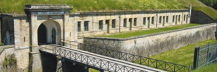
A French fort adapted by the Germans which was part of the first line of defences around Metz (1867-1918)


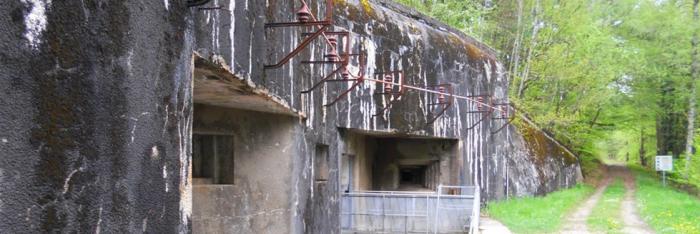
The Fort de Queuleu was part of the first chain of defensive fortifications around the city of Metz. Its construction, begun by the French under the Second Empire, in 1867, was largely resumed by the Germans following the annexation of Alsace-Lorraine after the Franco-Prussian War (1870-71). The fort had been occupied by French troops during the siege of the city between August and October 1870. The barracks, powder magazines, artillery positions, adjoining batteries, galleries of countermines and shelters all bear witness to the changes in military architecture and the advances in weaponry between the late 19th and early 20th centuries. Meanwhile, the central cavalry barracks constitutes a very fine example of Séré de Rivières architecture in Metz.


However, with the construction of Metz’s second chain of fortifications, beginning in 1899, the Fort de Queuleu lost its strategic importance and only minor alterations were made to it. As a result, the fort remains as it was in the second half of the 19th century.


During the First World War, it may well have been used by the Germans as a camp for French prisoners of war, although there is little information available on the subject. A complex network of trenches preserved outside the fort is evidence of the defences built by the Germans to safeguard Metz between 1914 and 1918.


A Nazi concentration camp in Metz (1943-1944)


During the Second World War, the fort served as a barracks for the soldiers of the Maginot Line. Following the defeat of 1940, it was briefly used as a detention camp for prisoners of war (a Stalag). Between March 1943 and September 1944, it went on to be used as a KZ-Außenkommando, or ‘subcamp’, subordinated to the Natzweiler-Struthof concentration camp, in Bas-Rhin, mainly for use by the SS. A hundred prisoners were held here, mostly German common-law criminals and Poles. Some were put to work on building the Metz-Frescaty airbase. It was one of the Reich’s westernmost concentration subcamps.


A special camp at the centre of Nazi repression in Moselle (1943-1944)


Between October 1943 and August 1944, a Sonderlager, or ‘special camp’, run by the Gestapo was installed in Barracks II. Between 1 500 and 1 800 prisoners (men and women) were interrogated and interned there before being sent to concentration camps (Natzweiler-Struthof, Dachau, etc.), ‘re-education’ camps (Schirmeck) or prisons. Among them were Resistance fighters, saboteurs, smugglers, hostages, those who tried to avoid the compulsory labour camps in Germany, and Russian prisoners. Most were held in overcrowded cells, unable to wash and not allowed to speak or move, under the brutal supervision of SS guards and camp commandant Georg Hempen. Resistance leaders were kept in solitary confinement - dark, dank dungeons to which only the commandant had access. The SS officers ‘industrialised’ interrogation and used torture. The conditions in which the prisoners were held were horrific, and most were cooped up blindfolded with their hands and feet bound. Thirty-six people died in the fort, while four managed to escape, in April 1944.


An important monument from the Battle of Metz (1944)


During the liberation of Metz, the fort had its baptism of fire between 17 and 21 November 1944, in fighting between the US army and German troops aided by the Volkssturm (armed civilians, First World War veterans, members of the Hitler Youth, etc.), who were entrenched here. The fort was severely damaged in the bombardment, before finally surrendering.


One of the biggest ‘guarded residence centres’ (1944-1946)


The fort was used as a centre de séjour surveillé, or ‘guarded residence centre’, by the French government between December 1944 and March 1946. Initially reserved for German civilians and their families, the site went on to serve as a detention centre for administrative internees arrested on charges of collaboration, propaganda, anti-patriotism or informing (up to 4 400 people were interned here). It was one of the largest centres of its kind in France. People of various nationalities were interned here, including French, Germans, Italians, Luxembourgers, Poles, Spaniards and Yugoslavs.


A camp for German prisoners of war (1946-1947)


Between 1946 and 1947, the Fort de Queuleu was a camp de prisonniers (‘prisoner camp’) for German soldiers. Assigned this purpose on 1 June 1946, it was subordinated to Depot 211 for prisoners of war in Metz. Run by Monsieur Massu, the camp was visited by the Red Cross on 13 February 1947. One hundred and forty-five prisoners were being held there at the time, in Barracks II/Pillbox A. The accommodation was heated, the rations were adequate and there was hot water for washing. An infirmary was run by Dr Dietrich Ostler. The prisoners were assigned to unloading goods trucks, clearing a canal and carrying building materials.


A camp for Indochinese workers (1948-1950)


To replace the mobilised workforce, the ‘Mandel Plan’, drawn up in 1938 by the then Minister for the Colonies, Georges Mandel, provided for colonial workers to be brought to France to take the place of those men who had been called up to fight. Around 20 000 workers from French Indochina arrived in France at the beginning of the Second World War. The labour ministry’s indigenous, North African and colonial labour service (MOI) was put in charge of recruiting the necessary colonial workers, shipping them to France and allocating them to the national defence industries. Most were recruited by force from among the poor peasantry of the protectorates of Annam and Tonkin and the colony of Cochinchina. These unskilled workers were used mainly as forestry, agricultural and industrial labour, in particular in the armaments factories and powder magazines. After the French defeat, they were lodged in huge camps in the Free Zone, where they were subjected to military discipline as well as very harsh living conditions. At Liberation, the majority wanted to return home as soon as possible, but their repatriation was delayed due to postwar disorganisation and events affecting French Indochina. As a result, several hundred Indochinese workers occupied the Fort de Queuleu between 1948 and 1950: 537 in October 1948, 438 in December 1948, 323 in March 1949, 296 in April 1949, 188 in May 1949, 163 in August 1949, 176 in September 1949, 213 in October 1949, 156 in December 1949, 191 in January 1950, 35 in April 1950 (repatriations to Vietnam gathered pace in this period) and 79 in May 1950. The suffering of exile gave way to exasperation and anger. Echoing the Vietminh independence movement in Indochina, the Indochinese workers in metropolitan France called for emancipation and equal rights with other workers. Graffiti on the walls of the Fort de Queuleu is a sign of their presence here.


A remembrance site (since 1971)


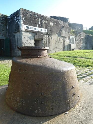
At the entrance to the fort stands a memorial to resistance and deportation, inaugurated on 20 November 1977, which marks the entrance to the remembrance site. The monument, containing the ashes of an unknown deportee, was designed by Metz-born architect Roger Zonca, who was involved in the reconstruction of the area.
 

Since 1971, the protection and promotion of the Fort de Queuleu in Metz has been the task of the Association du Fort de Metz-Queuleu pour la mémoire des internés-déportés et la sauvegarde du site (formerly the Amicale des anciens déportés du fort de Queuleu et de leurs familles), made up of volunteers.


Click on the photo of your choice to expand it 


From left to right: Entrance gate and entrance to the Nazi special camp - Cells
- Area damaged by the bombardments of 1944 - The commandant’s office
- Corridor of the camp - Main access bridge to the Fort de Queuleu.


Membership form


Sources : ©Fort de Metz-Queuleu

> Return to results

Practical information

Address

Rue du Fort de Queuleu/Allée Jean Burger - 57070
Metz
+33 (0)6 95 67 42 80

Weekly opening hours

Sunday afternoon, 2 pm to 5 pm/6 pm (according to season) http://www.fort-queuleu.com/visites/

Fermetures annuelles

Late December to early January Office de Tourisme de Metz - 2 place d’Armes - CS 80367 - 57007 Metz Cedex 1 - Tel.: +33 (0)3 87 39 00 00 - Fax: +33 (0)3 87 36 59 43 - Email: contact@tourisme-metz.com

Fort at Ivry-sur-Seine

Prise de vue aérienne du fort d'Ivry. ©Michel Riehl – Source : ECPAD

This fort, constructed between 1841 and 1845, was modified after the war of 1870 in order to defend Paris.

Now the property of the Communication and Audiovisual Production Company for the Department of Defence (E.C.P.A.D), the fort at Ivry-sur-Seine (Val-de-Marne), constructed between 1841 and 1845, was modified after the war of 1870 in order to defend Paris. It is part of the first line in Séré de Rivières' system.

Constructed between 1841 and 1845, the fort was equipped in 1870 with 94 artillery pieces and commanded by Sea Captain Krantz. It was defended by a marine battalion that had come from Brest. On the 29th and 30th November, the fort supported the attacks from the outposts of the 6th Prussian corps to the north of Choisy-le-Roi, Thiais and Chevilly-la-Rue. On the 30th these three villages received 5,500 shells in a single day. The besieging troops owe their salvation to the numerous trenches. The French abandoned the captured positions on the evening of the 30th. The fort was occupied by the 6th Prussian corps from the 29th January until the 20th March 1871. A battery of 21 cm mortars was brought into the gorge to fire on the central section and batteries of 15 cm cannons to bombard Paris in the event that fighting should start again. The townspeople occupied the fort after the departure of the Prussians, with Colonel Rogowski in command of the confederate garrison. Faced with the threat of an attack by troops from the 3rd Versailles corps, the Confederates evacuated the fort during the night of the 24th to 25th May, blowing up a munitions depot and destroying nine of the casemates between the 3rd and 4th sides.
The fort is a pentagon with 5 bastions. It is built on underground galleries; only one of the bastions is not entrenched in the foundation piers. The galleries (more than 2 km) were planned out between 1852 and 1860 to keep watch over these piers and serve as shelters from bombardments (the ceilings of these galleries are 6 m thick). During the works, 2 battalions from the 65th Line Regiment were used, housed in an army camp close to the fort. The dominant position of the fort is clearly visible from the crossroads to the north of the entrance. The entrance accommodates two guardhouses in five vaulted casemates. There are also three postern gates, of which 2 are next to the latrines, along the other sides. The ramparts and bastions are bridged by about fifty cross sections, including 28 with vaulted shelters. The rampart between bastions 3 and 4 protects 18 casemates; one of them had a bread oven. The flanks adjacent to the bastions have gun casements for the infantry. The four other ramparts have a scarp with protected walkway for the infantry. The parade ground is surrounded by a large barracks for the troops and two houses for officers. These buildings were rebuilt in 1872. The 2 gunpowder magazines have an internal surface area of 142 m2. The fort is served by 3 wells. The building is faced in millstone, with cut stone for the stays and window and door surrounds. The buildings have tiled or zinc roofs. The arches of the casemates and magazines are in stone. The ditches between bastions 1, 2, 3 and 4 are still preserved. To the west, a police barracks occupies the place of the ditches. On the glacis there are now gardens, a college, a school, some houses and other buildings. Access is still via a casemate guardhouse. The rampart has kept its cross sections and casemates, although the latter have been converted into offices. The three barracks rebuilt after 1872 have been redeveloped, along with the two gunpowder magazines dating from 1847.
The premises now house the Communication and Audiovisual Production Company for the Department of Defence (E.C.P.A.D). They store the audio-visual archives of the military history of France from 1900 to the modern day, through 16,800 films and videos and more than 3.5 million de photographs. The first world war collection collates all the pictures and films made by the Armed Forces Photographic and Cinematographic Division (SPCA) from 1915, the date it was established, to 1919 when it was suspended. This collection is made up of images directly linked to: fighting and its aftermath: the French front and the Eastern front, the lives of poilus (a slang term fro a French soldier), the army medical corps, prisoners and what remains of the battlefields; images of the economic effort of the country and its colonies; images of political and diplomatic life: official visits of heads of state or foreign delegations, the Treaty of Versailles etc. pictures and works of art, monuments and museums and photographs taken in anticipation of reconstruction. The second world war collection collates all the documents issued by the various forces represented: the phony war documents the life of the French armies in the countryside, from the North Sea to the Italian border, between the declaration of war and the start of the French campaign; Vichy is concerned with the actions of the government and the Armistice Army, mainly in the free zone in North Africa before the allied landings; The Liberating Army follows the main fighting that took place from North Africa to Europe, from Algiers in November 1942 until the liberation of the concentration camps in 1945.
The German collection is especially large, due to the great number of operational theatres illustrated along the eastern front and through the diversity in the subjects covered in the military field (scenes of fighting and training, the lives of units on the front, the repression of people in the east and the manufacture of weapons) and in everyday life. Managed by the Armed Forces Cinematographic Division (SCA) which was united after the war, the Indochina war collection groups together Tonkin, Annam, Cochinchina, Cambodia and Laos. Although military documentaries, most of which were about the land army, represent the main subject of this collection, there are also documents describing the way of life, habitat and special customs of the various ethnic groups. Many documents belonging to this collection illustrate French action in the colonies: keeping order, industrial and agricultural development, the construction of schools, housing and clinics and the establishment of administrative frameworks. They demonstrate approval of French presence in Indochina and Algeria. The external operations collection. Protecting France's fundamental interests can lead to the intervention of the armed forces outside their national territory. That is why we talk about external operations, carried out within the framework of international mandates, such as NATO and the UN. The main external operations covered by the ECPAD since 1945 are the Korean war (1952-1953), the Lebanon (1978-1984), Chad (1978-1987), Cambodia (1991-1993), the Gulf War (1991), Bosnia-Herzegovina (since 1992), Rwanda (1994), Kosovo and Macedonia (since 1998), the Ivory Coast and Afghanistan (since 2001).
Fort at Ivry-sur-Seine 2-8 route du Fort 94205 Ivry-sur-Seine Remembrance tourist information Mairie d'Ivry Esplanade Georges Marrane 94205 Ivry-sur-Seine cedex Tel.: 0149.60.25.08 Communication and Audiovisual Production Company for the Department of Defence (ECPAD) Tel: 01.49.60.52.00 Fax: 01.49.60.52.06 e-mail: ecpad@ecpad.fr or mediatheque@ecpad.fr

> Return to results

Practical information

Address

2-8 route du Fort 94205
Ivry-sur-Seine
Tourisme de mémoire Mairie d'Ivry Esplanade Georges Marrane 94205 Ivry-sur-Seine cedexTél. : 0149.60.25.08Etablissement de communication et de production audiovisuelle de la défense (ECPAD)Tél : 01.49.60.52.00Fax : 01.49.60.52.06e-mail : ecpad@ecpad.fr ou

Weekly opening hours

Se renseigner pour l'accessibilité au site

Joux Château

The château. ©Joux Château

With its five fortified walls, Joux Château demonstrates the development of fortifications over ten centuries.


The ten centuries of history of this fortress, the first constructions of which date from 1034, present developments made in defences on a 2-hectare site: the solid towers of the Middle Ages, the bastions from Vauban's era and the modern fort built in front of the château by Joffre in 1879.


Three ditches with drawbridges protect a world of prisons, from the dungeon which housed the legendary Berthe de Joux to the cells where Mirabeu, Kleist and Toussaint Louverture were confined.


A particularly memorable feature of the site is a large well, a vertiginous cylinder dug out of the rock.


A rich museum of weapons from the 18th and 19th centuries, which holds several particularly rare pieces, is a perfect complement to the visit.


In addition to the various exhibitions, visitors will see a scale model of the château measuring 3.64m by 1.76m complete with audio commentary.


Visits, talks, evening events and the Nuits de Joux festival in July-August are organised.


Joux Château

25300 La Cluse-et-Mijoux

Tel: +33 (0)3 81 69 47 95

e-mail: ccl-chateaudejoux@orange.fr

Official Joux Château website

> Return to results

Practical information

Address

25300
La Cluse-et-Mijoux
03 81 69 47 95

Prices

Adultes 6,5 € Enfants (de 6 à 14 ans) : 3,5 € Réduit : 5,5 € Famille (2 adultes et 2 enfants) : 17 € Enfant supplémentaire : 2 €

Weekly opening hours

Du 1er avril au 15 novembre : 10h à 11h30 et de 14h à 16h30 Juillet et août : de 9h à 18h Du 16 novembre au 30 mars : le château est susceptible d'être ouvert selon les conditions météo. Groupe toute l'année sur réservation

Fermetures annuelles

Musée d'armes anciennes fermé en hiver

Fort Uxegney

Courtyard, Fort Uxegney. Photo ARFUPE

Fort Uxegney is a striking summary of the development of fortification techniques between 1870 and 1914.
To defend the new frontier between France and Germany, in 1874 General Séré de Rivières began the construction of two lines of defence made up of forts and armed bases: one on the Hauts de Meuse, between Verdun and Toul, and another on the Haute Moselle, between Epinal and Belfort. Fort Uxegney, which lies 6km north-west of Epinal, is just one of the more important elements of the Place d'Epinal, consisting of a line of 16 forts and closed structures stretching along 43 kilometres. Built between 1882 and 1884, its purpose was to defend the road connecting Epinal and Mirecourt, the Epinal-Nancy railway line and the canal to the east. In addition, the fort had to defend neighbouring structures, in particular Bois l'Abbé (1883-1885) a structure 1200 metres east of Fort Uxegney made entirely of masonry and with an excellent view of the Séré de Rivières system.
Moreover, Bois l'Abbé differs from Fort Uxegney which, after modernisation in 1894 (using special concrete to reinforce part of the central barracks, the explosives storeroom and the undercover passage) and 1910 (the use of reinforced concrete on certain parts of the fort, the installation of armoured turrets used as observation posts), is a striking summary of the development of fortification techniques between 1870 and 1914.
Abandoned by the army in 1960, Fort Uxegney, which was miraculously spared from destruction during the two world wars, has been maintained and restored since 1990 by the association for the restoration of Fort Uxegney and Place d'Epinal (ARFUPE). Since April 2002, thanks to the passionate work of some twenty volunteers from that association over almost 15 years, the fort and the Bois l'Abbé are registered on the supplementary list of historical monuments.
During visits, it is now possible to discover, through the numerous underground galleries, the electricity generation plant, the kitchens, the barracks, and, above all, the last remaining operational Galopin rotary retractable turret (155mm), a giant machine constructed in 1907. A walk beneath the structure also gives the visitor the opportunity to examine the different armoured domes and enjoy a superb view of the Avières valley.
Now recognised by professionals in the tourism industry, Fort Uxegney could, with the support of the ministry of defence (DMPA) become a site of real historical interest in terms of the Séré de Rivières fortification.
Opening dates and times Guided tours May 2009 - Sunday: 15h From the 1st of July to the 31st of August Guided tours - Monday to Saturday: 14h and 16h - Sunday: 14h, 15h and 16h Open all year round for groups with appointment Duration of visit: 1 hour 30 minutes to 2 hours Bring warm clothing Prices Adults: 5 € Groups of more than 15: 4 € Children 7 to 14: 1.50 € children fare : 1 € Contacts Tel.: (+33) 3 29 38 32 09 ARFUPE Rue des forts 88390 UXEGNEY E-mail: fort-uxegney@orange.fr Epinal Tourist Office 6, place Saint-Goëry BP 304 88008 Epinal Cedex Tel.: (+33) 3 29 82 53 32 Fax: (+33) 3 29 82 88 22 E-mail: tourisme.epinal@wanadoo.fr
> Return to results

Practical information

Address

Rue des forts 88390
Uxegney
Tél. : 03.29.38.32.09. Office du tourisme d'Epinal 6, place Saint-Goëry BP 304 88008 Epinal Cedex Tel : 03 29 82 53 32 Fax : 03 29 82 88 22

Prices

6 € (adultes) 5 € (groupes > 15 personnes) 2,50 € (enfants de 7 à 14 ans) 2 € (tarif réduit enfants)

Weekly opening hours

Mai : visites guidées le dimanche à 15 h Juin et septembre : visites guidées le dimanche à 15 h et 16 h Du 1er juillet au 31 août : visites guidées du lundi au samedi à 14 h et 16 h. Le dimanche à 14 h, 15 h et 16 h Toute l'année pour les groupes (à partir de 15 personnes), sur rendez-vous. Visites exceptionnelles du fort de Bois-l'Abbé 14 juillet et le dimanche des Journées du Patrimoine Décembre : Marché de Noël du fort d'Uxegney Visites guidées du fort à tarif réduit (4 euros et 1 euro)

Fort Simserhof, Siersthal

Ouvrage du Simserhof. ©SporRegArm. Source : http://communes.sporegarm.fr

Fort Simserhof, one of the most significant and well-preserved artillery forts on the Maginot Line.

Lying 8 km west of Bitche on the edge of the village of Siersthal in the département of Moselle (Lorraine), Simserhof, with its 5 kilometres of subterranean galleries (including 1,700 metres of rail), 2 entrances (one for soldiers, one for munitions) and 8 blockhouses, is one of the most significant and well-preserved artillery forts on the Maginot Line. Built between 1929 and 1935, Simserhof, which was built in the fortified sector of Bitche, possessed great firepower. It was manned by 876 soldiers and gunners from the 150th and 155th Infantry Regiments, as well as troops from the 152nd Fortress Infantry Regiment, sappers and miners, electrical engineers, railway sappers and transmissions engineers were permanently stationed at the giant underground fortress. From the 10th of May 1940, the start of the Blitzkrieg, these soldiers, commanded by Lieutenant-Colonel BONLARRON heroically withstood numerous offensives by the German army. Undefeated, they put down their weapons on the orders of the French High Command on the 30th of June 1940, 5 days after the cease-fire, and then returned to the camp at Bitche, the first step on the way to captivity in Germany. Following fierce fighting 4 years later, between the 3rd and 19th of December 1944, two American divisions took back the fort from the Germans.

The property of the Defence Department, the whole of the site has been entrusted to the Moselle département and the Bitche regional council and has been the subject of large-scale improvements to promote its cultural and tourism appeal. Reopened to the public on the 14th of July 2002, the tour is in two parts. First of all there is an 18-minute film on a giant screen. Made by Gabriel LEBOMIN and the Communication and Audiovisual Production Company for the Department of Defence (ECPA-D), it tells the history of the Maginot line from 1918 to 1940.
Then, on board automatic vehicles equipped with sound systems, the tour takes you through the munitions entrance right into the heart of the building. Here begins a 30-minute journey through the galleries of Simserhof, with commentary by the actor Bruno PUTZULU who plays a fictional soldier from 1940, bringing the daily life of the company, the military architecture and the fort's firepower to life for the public. His story ends, in the middle of a racket of cannons and shells, with Fort Simserhof 's 50 days of fighting. Other parts of the fort will shortly be restored. The public will then be able to visit the barracks, a real underground town, comprising most notably of the infirmary -ultra-modern at the time - equipped with a pharmacy, operating theatres and a decontamination room for gas victims, the soldiers' bar area, in which the gunner Romain Simon, a set designer at the Opéra in Paris, painted frescoes inspired by the Walt Disney cartoon, Snow White and the Seven Dwarfs, electric operated kitchens and officers' and troops' accommodation. You will also be able to take a look at the electricity production plant and its machinery room, comprising 4 impressive Sulzer diesel generators (6 cylinders, 265 CV) whose fuel consumption is 66 litres/hour.
Opening hours: From 15/03/2011 to 15/11/2011: 10 am to 5 pm (6 pm in July and August), closed Mondays except holidays and July and August Free parking Reservation is strongly recommended and compulsory for groups (personalised service is provided for groups). - Due to the low temperatures in the galleries of the fort (+/-10°C), bring warm clothing - Access for visitors with restricted mobility - A schedule of reconstructions, exhibitions and events is available on request - A fast-food cafeteria - Shop selling souvenirs, artisan products and local products Prices Individuals: Adults 12 € / Children (6 to 16 years): 8 € Adult groups (minimum of 20 paying adults): 10 € Children's groups (minimum of 10 paying children): 7 € Free for children under 6 Reduced entry fee upon presentation of student, job-seeker or war veterans card Information and reservations: Simserhof - Rue André Maginot - " Le Légeret " - 57410 Siersthal Telephone: +33 (0)3 8796 3940 Fax: +33 (0)3 8796 2995 E-mail : resa@simserhof.fr

> Return to results

Practical information

Address

Rue André Maginot 57410
Siersthal
03 87 96 39 40

Prices

Tarif adulte: 12 € Enfant de 6 à 16 ans: 8 € Groupes: 10 € par adulte (à partir de 20 personnes) 7 € par enfant (à partir de 10 enfants) Gratuit : Enfant (- de 6 ans)

Weekly opening hours

Du 15 mars 2011 au 15 novembre 201: de 10h à 18h (17h hors juillet et août)

Fermetures annuelles

Fermé le lundi sauf jours fériés et en juillet et août.

The Citadel of Belle Ile

Citadel of Belle Ile. Photo: ECPAD

The Citadel of Belle Ile en Mer has played a role in France's great history. Since the 16th century, it has been the scene of every conflict and coveted by all of Europe's naval powers.

The citadel extends over more than 10ha and has ramparts 4km long. The citadel is composed of around a dozen buildings totalling over 10,000m2 of floor space, not counting the many blockhouses. Built from 1549, it still has an impressive system of ditches. Belle-Ile became the property of the crown in 1661 after the arrest of superintendent Nicolas Fouquet. In 1683, Vauban was charged with fortifying this island. It was occupied by the English from 1761 to 1763. In the 19th century, the citadel was used as a penal colony for prisoners of war and then political prisoners before becoming a reception centre for refugees of the Spanish Civil War at the end of the 1930s. From July 1940, the island was occupied by the Germans. It was to be one of last parts of France to be liberated as it was part of the famous "Lorient pocket". The French government sold the citadel in 1960, by which time it had fallen into a state of serious disrepair.


Creation of an historical museum in 1970 devoted to Belle-Ile-en-Mer on the site of the dungeon's ancient blockhouses. Citadelle Vauban 56360 Le Palais Tel: 02 97 31 85 54 Fax: 02 97 31 89 47 Rates Free visit: adult: 6.50 € 12 to 16 years: 3.50 € - 12: Free Group: 5 € Guided Tour: Adults: 8 € 12 to 16 years: 5 € - 12: Free Open daily all year July-August: 9h/19h from 01/09 to 31/10 and from 01/04 to 30/06: 9h30/18h from 01/11 to 31/03: 9h30/17h

> Return to results

Practical information

Address

56360
Le Palais
Tel: 02 97 31 85 54 Fax: 02 97 31 89 47

Prices

Visite libre : adulte : 6.50 € de 12 à 16 ans : 3,50 € - de 12 ans : Gratuit Groupe : 5 € Visite Guidée : adultes : 8 € de 12 à 16 ans : 5 € - de 12 ans : Gratuit

Weekly opening hours

Ouvert tous les jours, toute l'année juillet-août: 9h/19h du 01/09 au 31/10 et du 01/04 au 30/06: 9h30/18h du 01/11 au 31/03: 9h30/17h