Newsletter

Cambrai

La Nécropole allemande de Cambrai. Photo Licence Creative Commons. Libre de droit

The German Necropolis in Cambrai.

The cemetery on the Route de Solesmes

Located on the road to Solesmes, this cemetery not only evokes the fate of this town, occupied by the Germans from 26 August 1914 to 9 October 1918, but most importantly the first battle of Cambrai, from 20 November until 3 December 1917, the German offensive of March 1918 and this second battle of Cambrai, the last battle on the Hindenburg line, which was to finally liberate the city in October 1918, the town by then having endured terrible destruction.


Later the town was "adopted" by the County Town of Birkenhead. The cemetery had been created by the Germans during their occupation from March 1917. They had constructed a few monuments and a stone cross there. On 11 August 1918, the Bavarian commander of the town had handed over the maintenance of the cemetery to the town. Afterwards the German Military cemetery that was in Cambrai was transferred there to the Saint-Sépulcre cemetery. The graves have now been regrouped. The remains of 10,685 Germans, 192 Russians, 6 Romanians and 502 British are to be found there.

13 km to the north east of Bapaume on the road between Cambrai and Bapaume is the Louverval Memorial. It commemorates the 7,048 British and South African soldiers who died at the Battle of Cambrai in November and December 1917 and whose graves are unknown. The Battle of Cambrai, marked by a breakthrough on 20 November, a cessation on positions on 22 November and a German counter attack between 23 and 29 November, resulted in a limited gaining of ground but taught the Allies some valuable tactical and strategic lessons. For their part, the Germans had discovered that their line of defence was vulnerable. The Memorial, situated on a terrace at the far end of the military cemetery, was designed by H. Chalton Bradshaw and the sculptor C.S. Jagger, whose two bas-reliefs illustrating battle scenes are to be admired.


1917 had been a terrible year for all the fighting nations during the ongoing First World War. At the end of the year, the British, seeking to destroy the Hindenburg line (the defensive system for the territories occupied by the Germans), decided to launch an offensive to the south of Cambrai involving the large-scale use of tanks. The battle was merciless: the first battles were a great success for the British troops, except at Flesquières, but the Germans, at first thrown into confusion, very quickly started a powerful counter-offensive. For 15 days, attacks and counter-attacks were to follow in succession, with neither of the two armies chalking up decisive success. The human losses were enormous: 45,000 British and 55,000 Germans were killed, as whole villages were destroyed. During the First World War, a new weapon appeared on the battlefields: the tank. Tanks were designed to support the attacks of the infantry, driving them across enemy lines. During the battle in November 1917, the "Tank Corps" of the third British Army (a total of 476 tanks) was engaged to break through the Hindenburg line.


The objective of the battle was to take the strategic positions of the Flesquières ridge and the Bourlon woods before targeting the liberation of Cambrai. At Flesquières, the British attack came up against fierce resistance from German troops, who managed to destroy or immobilise several tanks. One of those destroyed was buried by the Germans in the spring of 1918. In November 1998, thanks to a handful of enthusiasts, it was unearthed. Today this war relic can be seen in Flesquières. At Cambrai, the memory of this battle lives on through the monument to the soldiers from the Cambrai regiments, opposite the gate to the citadel and through the French Remembrance monument listing all those from Cambrai who died in combat during the Great War. The Louverval cemetery is an important place of remembrance for them.


Characteristics: - 26.5 tonnes - 8.50 metres long - 3.20 metres wide - 52 cm wide tracks - 5 machine guns with 13,000 to 30,000 cartridges - Crew of 8 men.
It was on the Flesquières ridge that the most important episode of the Battle of Cambrai took place. Overlooking the valley, it is possible for us to imagine the starting point of the British attack on 20 November 1917, on a front of about 8 km stretching from Havrincourt to Bonavis. There used to be a mill there, but since it could be used as a reference point for the British artillery, it was destroyed by the Germans. Today there is a project to build an orientation table showing the Hindenburg line's defensive system and erect a monument to the glory of the soldiers who fell on the battlefield.


This raised German bunker is characterised by its shape and its use, as it served as an observation tower. In fact, its position allowed communication with Cambrai using visual signals. The observation post was attached to the château garden. The building is still very well preserved today.


An exact replica trench was created for the filming of the documentary "he Trench" by the BBC. Tours of the site are possible on request to complement a tour of the tank.


Flesquières Hill British Cemetery

In this cemetery, as in all those with more than 400 graves, the Commonwealth War Graves Commission has built a "Remembrance Stone" on which is engraved the inscription "Their Name Liveth For Evermore". In addition, the cemetery contains the graves of 589 known and 332 unknown soldiers. Next to the British are buried the soldiers from New Zealand and Australia who took part in the fighting at the end of the war.


Orival Wood British Cemetery

The remains of the famous English poet, Lieutenant Ewart Alan Mackintosh are buried here. In the same place there are also the graves of Canadian and German soldiers killed in the Flesquières sector.

> Return to results

Practical information

Address

Route de Solesmes 59400
Cambrai
Tél: 03.27.73.21.00Fax: 03.27.73.21.01

Weekly opening hours

Accessible toute l'année

Bertheaume Fort

Fort de Bertheaume. Source : GNU Free Documentation License

This construction, which was fortified by Vauban in the 17th century, surveys the entrance to the Brest narrows.


This 38 metre high islet with its natural beauty, battered by wind and tide, overlooks the entrance to the Brest Narrows. Protected by the sea but accessible at low tide, it has been used as a refuge since prehistoric times. Its position made it highly coveted, and the Dukes of Brittany set Le Perzel Château on it in the 5th century. However, its moment of glory came during the 17th century, when the King's engineer proposed that the island be fortified by building on the existing ruins. Vauban established a battery which was involved in driving back the English.


At the end of the 19th century, the islet was abandoned and a more powerful battery was created on land, behind it. The last time it was armed was by the Germans, who sited 75mm and 20mm canons on it, and hid machine guns around the fort. Under heavy bombardment, it surrendered to American troops in September 1944.


Bertheaume lay abandoned for 45 years until it was reborn out of its turbulent history in 1992. After Herculean restoration work (when workmen physically carried materials to the site) it was opened to the public once again.


Today, the accurately restored site invites you to discover its past through numerous exhibitions and events.


Bertheaume Fort

Tel: +33.(0)2.98.48.26.41


Group visits can be arranged on request. Evening visit entitled "Tales of Bertheaume": every Wednesday in summer


Open April to November: 5 April to 4 May 2pm to 6.30pm every day. 5 May to 27 June and 6 to 28 September, 2pm to 6.30pm Tuesday to Sunday. 28 June to 31 August: 10am to 7pm.
October: 2pm to 6pm on Wednesdays and Sundays, 25 October to 2 November 2pm to 6.30pm every day. Open 2pm to 6pm on 5, 8, 9, 10 and 11 November.


Ticket office closes 1 hour before the site.
 

Entrance: Adults: €3.80 Preferential rate: €2.90 Reduced tariff (young people aged 12-18, students and job seekers): €2.10 Children aged 6-11: €0.80
 

Plougonvelin village official website


> Return to results

Practical information

Address

fort berthaume 29217
plougonvelin
02 98 48 30 18

Prices

Plein tarif: 2 € Gratuit : Moins de 11 ans

Weekly opening hours

DU 30 juin au 31 août: 11h à 18h

Gros ouvrage Maginot du Hackenberg

VENEZ VISITER LA LIGNE MAGINOT EN METRO.


La visite de ce gros ouvrage de la Ligne Maginot apporte un nouveau regard sur une formidable fortification de ce XXème siècle et sur la Seconde Guerre mondiale.

Avec ses 19 blocs de combat et ses 10 km de galeries, l’ouvrage du Hackenberg est le géant de la Ligne Maginot.

Sa construction débuta dès 1930 parmi les tout premiers. Il fut en fait le prototype des ouvrages d'artillerie de la ligne Maginot. 1800 ouvriers environ travaillèrent avec des moyens relativement rudimentaires pendant six années pour construire les 19 blocs de combat et percer environ 10 kilomètres de galeries. Après 1933 et l'achèvement du gros oeuvre, on installa l'équipement intérieur et l'armée française prit livraison de l'ensemble en 1936.

Après la déclaration de guerre en 1939 et la période de vigilance maximale de la 'Drôle de guerre', le Hackenberg remplit son rôle lors de l'offensive allemande de 1940 et sa reddition ne fut effective que quelques jours après l'armistice. En novembre 1944, il fut investi par la 3e armée américaine du général PATTON lors de la terrible bataille pour la libération de la Moselle.

Sous la conduite d’un guide de l’association AMIFORT, le public y découvre des installations d’origine en parfait état de fonctionnement, une usine électrique et des groupes électrogènes en état de marche, des salles reconstituées à l’identique et un musée militaire.

La visite se poursuit à bord du petit train d’époque qui transporte les visiteurs vers les blocs de combat, dont l’imposant bloc 9 où l’on peut assister à la démonstration du fonctionnement de sa tourelle d’artillerie de 163 tonnes.

Après une sortie en surface, les visiteurs découvrent le bloc 8 qui porte encore les stigmates des combats de 1944 entre les troupes allemandes et américaines.

C'est un voyage dans le temps et dans l'Histoire d’une formidable fortification du XXème siècle que les bénévoles et salariés de l'association AMIFORT vous proposent.

L’ouvrage du Hackenberg est l’un des très rares ouvrages militaires possédant un circuit pédestre balisé par le Club Vosgien qui vous permet d'admirer les dessus de ces 19 blocs de combat en transitant par le Mur Antichar de 800 mètres de long et 8 mètres de haut, une curiosité unique en Lorraine.

La visite du fort dure environ deux heures et se déroule dans un environnement souterrain où la température est stabilisée à 12° toute l'année. Pour votre confort prévoir des vêtements en conséquence.

Compte tenu des contraintes liées à la visite d'un ouvrage souterrain ancien à plusieurs niveaux, seule la découverte de quatre-vingt pourcents du parcours est assurée pour les personnes à mobilité réduite. Les poussettes sont acceptées.

Une boutique souvenir vous est proposée à la fin de la visite.


Sources : ©GROS OUVRAGE MAGINOT DU HACKENBERG - PHOTOS libre de droit Crédit photo association AMIFORT
> Return to results

Practical information

Address

Association AMIFORT - 61 BIS GRANDE RUE 57920
Veckring
03 82 82 30 08

Prices

- Plein tarif 10 €- Jeunes de moins de 16 ans 5 €- Groupes 7 €- Gratuité pour les enfants de moins de 4 ans et les responsables de groupe- Pass/tarifs groupés éventuels 7 €

Weekly opening hours

Ouvrage ouvert au public 7 jours sur 7 Pour les groupes : matin et après midiPour les visiteurs individuels : du lundi au vendredi départ à 14h30 précises etLes samedis, dimanches et jours fériés départ dès 14h puis toutes les quinze minutes jusqu’à 15h30 (15h30 dernier départ pour 2h30 de visite guidée)

Fermetures annuelles

Du 22 au 25 août 2016 et le 1er novembreOffice de tourisme de référence : 16 rue du vieux collège - 57100 Thionville

Bazeilles

The Last Cartridge, from the painting by Alphonse de Neuville. ©Musée de la dernière cartouche

The museum at the House of the Last Cartridge is one of the most striking sites recalling the war of 1870. The famous painting "The Last Cartridge", by artist Alphonse de Neuville is displayed here.

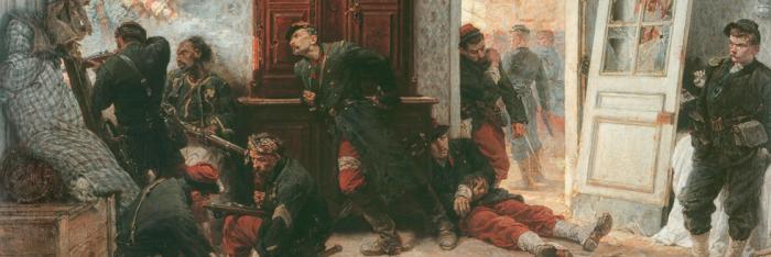
The House of the Last Cartridge "Thanks principally to the actions of Captain Aubert, the house was quickly readied as a last line of defence; taking a rifle, this brave officer positioned himself by one of the windows, and thanks to his wonderful example, his men kept their heads and followed his lead.


However, despite suffering heavy losses, the enemy continued to advance. Seeing that our house was about to be surrounded and being unable to walk, I tried to persuade the officers who were with me to leave me with a few men and to withdraw the majority of the division. Not a single one agreed and they all declared that they would remain with me to defend to the end... After two hours we were completely surrounded by the 15th Bavarian Regiment.


Our house was soon in a most piteous state; gaping holes in the doors and windows; our roof was half taken off by a shell that wounded four or five men. Despite this, the fight continued relentlessly. It only ended when our ammunition ran out." Commandant LAMBERT, Rapport sur la bataille de Bazeilles ("Report on the Battle of Bazeilles"), in HABENECK Charles, Martyr Regiments, Paris, Pagnerre, 1871.

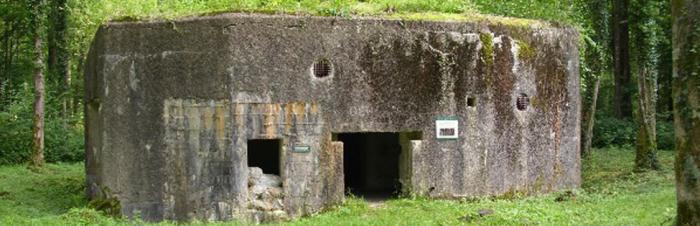
The museum at the House of the Last Cartridge is one of the most striking sites commemorating the war of 1870; it recalls the two days of fighting between the two brigades of General de Vassoigne's Blue Division of Marines and the Bavarian soldiers commanded by General Von der Tann. The battle got properly underway around noon on 31st August when General Martin de Pallières's second brigade received the order to retake the strategically important village of Bazeilles, which had just fallen into enemy hands. After a day of fierce fighting and thanks to the reinforcements from General Reboul's 1st Brigade, which arrived around 4pm, the village was completely retaken by nightfall. But at dawn on 1st September, General Von Der Tann's soldiers attacked Bazeilles once again. Despite many assaults that enabled the enemy to be driven back several times, at the end of the morning the Marine Division - overwhelmed by the Bavarian numerical advantage and firepower - was forced to retreat towards Sedan. It was at this time that the episode known as the House of the Last Cartridge took place.


In a burnt out village, destroyed by artillery fire from the day before, around thirty officers, NCOs and men from the Marine infantry took cover, alongside Commandant Lambert, in the modest two-storey inn belonging to the Bourgerie family - the last house in the village of Bazeilles on the road to Sedan. Here, for almost four hours, they put up fierce resistance to the Bavarian troops. At last surrounded and out of ammunition, in mid-afternoon Captain Aubert fired the last cartridge from the window of the master bedroom on the first floor. A white handkerchief tied to a rifle then announced the marsouins' surrender with Commandant Lambert, wounded in the foot, the first to leave the house. Throughout the hours of the battle, the Marine Division lost 2,700 men including around a hundred officers.
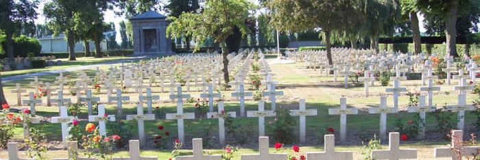
The Bavarian soldiers lost more than twice that number; the day after the fighting they began a series of horrifying reprisals against the population of Bazeilles, some of whom had taken the side of the Marine Troops; the village was set on fire, with some inhabitants shot, burned alive or arrested and deported. Civilian victims from the village numbered more than forty. For this heroic resistance, Bazeilles was awarded the Légion d'honneur in 1900, an emblem still found today on the town's crest, alongside the anchor of the marine troops and a house in flames. Following the defeat, the town also became an important site of remembrance and pilgrimage. Thus, on 19th March 1875, the Courrier des Ardennes published an article in which a museum in Bazeilles was announced: "Mr Bourgerie and his son, along with others, have collected a considerable number of objects, which together form an extremely interesting museum. Objects were exhibited in one of the ground floor rooms of the house. In May of the same year, General de Vassoigne visited the ruins of the House of the Last Cartridge and an initial monument was erected there in November opposite the church. But the first major ceremony took place on 31st August 1895, 25 years after the events, attended by the former Commandant Lambert, who by then was a General.


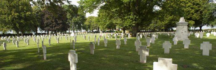
But it wasn't until 1899 that Arthur MEYER, director of Le Gaulois newspaper, launched a public appeal to finance the purchase of the house in order to "convert it into a modest museum dedicated to the memory of the heroes who died there". On 1st August 1909, the paper finally handed it over to the French heritage organisation Le Souvenir Français. Nevertheless, it was not until 3rd September 1950 that the first national commemoration of the fighting of 1870 was held. That same year, with the agreement of le Souvenir Français, the upkeep, administration and management of the Bazeilles museum was placed in the hands of National Committee for the traditions of the Marines, which also owns museum collections. To this task was added the management of the ossuary, built between 1876 and 1878 a hundred or so metres from the museum that contains the remains of 3,000 German and French soldiers


The House of the Last Cartridge, which receives 2,000 visitors a year on average, is currently closed, following the decision of the National Committee for the traditions of the Marines to restore it. Part of the work will be to upgrade the facilities and make them safe. The museum-related work carried out by specialists Mostra Conseil, will enable the house to retain its authentic feel and moving character whilst making it more attractive through the use of new technology. On the ground floor, visitors will find a reception area and the first museum exhibition room, called the Lambert room, dedicated to the 1870 war and the role of the Marines in this conflict. On the first floor, the Delay Room presents the Battle of Sedan. But the museum's most significant exhibits will be found in the Aubert and Lambert Rooms. The former will recount the fighting over Bazeilles whilst the latter, including the bedroom from where the final action was fought, will honour the memory of The Last Cartridge. In this room visitors will find Alphonse de Neuville's famous work painted in 1873, entitled "The Last Cartridge". Eventually, the Marines' Museum will form part of the "Remembrance Centre" that the Sedan regional authorities hope to establish in Sedan itself, and which will enable the main remembrance sites of the area to form a network.
The issue of accepting disabled people was studied and partly resolved by the construction of a specially adapted toilet block. However, those in wheelchairs are unable to visit the first floor. To allow them to do so would have involved demolishing the house and rebuilding it around a specially adapted staircase. Eventually, the Marines' Museum will form part of the "Remembrance Centre" that the Sedan regional authorities hope to establish in Sedan itself, and which will enable the main remembrance sites of the area to form a network.


Nota (1) - This division, composed of the four infantry regiments (1, 2, 3 and 4) and the 1st Marine artillery regiment, had originally been assembled with a view to carrying out a deception manoeuvre in the Baltic sea. The disasters suffered in the Alsace and in Lorraine during the initial battles forced the French high command to regroup its available forces at the camp at Chalons sur Marne in order to lend a hand to its Eastern army (Bazaine) trapped in Metz. Christened the "Blue Division" because of the colour of their uniforms, it was part of the 12th Army Corps (General Lebrun), making up its 3rd division (the two others, having been hastily cobbled together from staff picked up in warehouses and enlisted or conscripted young people, did not constitute solid units). It comprised of soldiers, the majority of whom were enlisted and experienced and had undergone severe training in distant campaigns and were already hardened. Its officers had earned their stripes under fire and the upper ranks had acquired sound fighting experience. The civilian population was well aware of this, giving them a warm welcome wherever they went.


La Maison de la dernière Cartouche

12 rue Dernière Cartouche - 08140 Bazeilles

Tel: 03 24 27 15 86


http://musees-de-france-champagne-ardenne.culture.fr/musee_bazeilles.html


A tableau of a heroic episode during the 1870 war depicting the Marine division known as the "Blue Division" Now completely renovated, the museum tells the story of the battles from the 31st August until the 1st September 1870, with pictures, armour and uniforms of the time.


The museum is closed on Mondays and Tuesdays.

Closed annually from the 20th December until the 15th January.

Museum tours from the 15th June to the 30th September from 10 am to 12 pm and from 1.30 pm until 6 pm

From the 1st October until the 14th June 10 am to 12 pm and from 1.30 pm until 5 pm

> Return to results

Practical information

Address

12 rue Dernière Cartouche 8140
Bazeilles
03 24 27 15 86

Prices

Adultes : 3 € Enfants : 1,50 € Militaires et anciens combattants : 1,50 € Groupes adultes: 1,50 € Groupes enfants: 0,50 €

Weekly opening hours

Du 15 juin au 15 septembre : 10h-12h et 13h30-18h Du 15 septembre au 15 juin : 13h30-17h

Fermetures annuelles

Fermé le lundi et le mardi. Fermeture annuelle du 15 décembre au 5 janvier

Hirson

Un des blockhaus d'Hirson. Source : http://fortifs.over-blog.com/


The Hirson Blockhouse line.


In the forest of Saint-Michel-en-Thiérache, near Hirson, there is a line of blockhouses built starting in 1936 and which were not part of the Maginot Line. Along the Belgian border, they form the connection between the fortifications of Maubeuge and those of the Ardennes. At first, only block shelters were built.


In 1940, although not yet completed, they provided support for two lines of combat positions: the front line – Ligne Principale de Résistance (LPR – Main Line of Resistance), and the rear line – Ligne d'Arrêt (LA – Stop Line), where the reserves in charge of the counterattack were located.


An anti-tank ditch and a network of anti-personnel barbed wire rounded out this double line.
The LPR and the LA contained imposing blockhouses equipped with cannons and machine guns.


On 18 May 1940, the Germans slipped between these two lines and took control of these positions.


A marked forest path is being set up. Furthermore, there is currently a project for a monument commemorating the fighting. Once the project is completed, some sites will accessible by car and hikers will be able to enjoy marked trails with explanatory signs for understanding the sites.


> Return to results

Practical information

Address

2500
Hirson
08 99 23 45 79

Weekly opening hours

Accès libre

Condé sur l'Escaut

Condé sur l'Escaut, the ramparts and the étang de Chabaud Latour. Source: http://lesjoyeuxgodillots.fr

The fortifications of Condé sur l'Escaut.


Only some 350 m of the medieval walls on either side of the Vautourneux Gate remain, comprising earthen ramparts doubled with a ring of towers and curtain walls that protected Condé until the middle of the 17th century. On one side, at the two ends of the earthen rampart wall, Archers Tower and Plovière Tower overlook the Nervien ditches. On the other side, the less impressive wall was defended by the Capucins Tower, rebuilt in 1623 and equipped with cannon firing ports strangely placed at ground level. Further on, the Touquet bartizan is set in an inside corner. We should also mention the so-called "Arsenal" fort and the Hotel de Bailleul, dating from the 15th century, with 4 turrets.


La fortification bastionnée remonte à l'époque des Pays-Bas, des conquêtes espagnoles et la décision prise en 1654 d'ériger la cite en place forte pour faire face à Louis XIV. Les Espagnols commencent à établir une fortification bastionnée au nord puis au sud et au sud-est. En 1674, les travaux étaient terminés, bastions, courtines, fossés et glacis, tout cela en terre, il est vrai mais en 1676 les quatre principaux bastions étaient muraillés.


Après la prise de Condé par Louis XIV en 1676, des améliorations sont apportées par Vauban : construction de contre gardes, renforcement de la redoute du Jard mais surtout il s'employa à murailler ce qui ne l'était pas encore. Le canal du Jard servait en partie de fossé de fortifications, en partie de canal d'inondation.

The bastioned fortification dates from the Netherlands period, the Spanish conquests and the decision taken in 1654 to make the city a stronghold against Louis XIV. The Spaniards began with a bastioned fortification to the north, and then to the south and southeast. The work was completed in 1674, with bastions, curtain walls, moats and glacis, all in earthenwork, but in 1676 the four main bastions were walled off.

Vauban made improvements after Condé was taken by Louis XIV in 1676, building counterguards, reinforcing the Jard redoubt, but he especially worked to build walls in areas that had not yet been walled off. The Jard Canal was partially used as a fortification moat and partially as a flood canal.

Today there remain eleven hectares (27.5 acres) of fortifications including the Jard, Solre, la Teste (or Royal) and Tournai bastions with ravelins and counterguards. Under the glacis of the Tournai ravelin there are countermines dug by the Austrians in 1794. The stronghold was decommissioned in 1901 and dismantled in 1913. Walking paths have been laid out to visit the ramparts and the Tourism Office organises guided tours. The city is a member of the association for fortified cities of the Nord-Pas-de-Calais region.


Valenciennois Tourism Office

"Le Beffroi" 26, place Pierre Delcourt 59163 Condé sur l'Escaut

Tél : 03 27 28 89 10

Fax : 03 27 28 89 11

Courriel : otduvalenciennois@wanadoo.fr


Quizz : Forts and citadels

> Return to results

Practical information

Address

59163
Condé-sur-l'Escaut
Tél : 03 27 28 89 10Fax : 03 27 28 89 11

Weekly opening hours

Accessible toute l'année

Assevent National Cemetery

Assevent military cemetery. Source: Ville d’Assevent


Click here to view the cemetery’s information panel vignette Assevent

Maubeuge, located at the intersection of railway lines that, coming from Brussels and Liège, converge towards Paris – was a major strategic goal for both the French and the Germans.

In accordance with the Schlieffen plan, German troops entered Belgium on 4 August 1914, and Maubeuge was on their way there. On 29 August, the Germans set off a powerful bombardment. After eight days of siege, Maubeuge was still resisting, but the situation turned highly critical from 6 September. On 7 September, General Fournier, the Governor of Maubeuge, had to capitulate. The Germans took 450,000 prisoners and 450 guns and 80,000 shells.

During the war, Maubeuge was controlled by the German military administration in occupied Belgium. It was only released on 9 November 1918 by British troops.

The Assevent National Cemetery, located 5km from Maubeuge, is home to the bodies of soldiers who died for France during the Siege of Maubeuge in August 1914.

Established in 1916 by the German army, the cemetery was redeveloped in 1923 to gather the bodies of other soldiers killed during the battle that were exhumed from temporary cemeteries in the Nord department or from Ypres in Belgium. The cemetery holds 1,819 bodies, including 364 in individual graves and 990 in four ossuaries, which is likely to include a large number of Moroccan infantrymen. There is a German military cemetery on the other side of the railway line. It was built in 1924 and comprises of 998 bodies of soldiers who fell in September 1914 around ​​Meaux (Seine-et-Marne).

The Assevent National Cemetery was established by the Germans during the war and seems to reconcile German, French, Russian and British soldiers in death.

> Return to results

Practical information

Address

59600
Assevent

Weekly opening hours

Open throughout the year

Seclin

Fort de Seclin. Source : https://fortseclin.jux.com

Seclin fort, cavalry and artillery museum.

Apart from the architectural masterpieces of the old hospital and the collegiate church, the town of Seclin also boasts a Séré de Rivières Fort that was part of the fortifications designed to protect the City of Lille and the surrounding area. But it could not keep pace with the development of late 19th century artillery and could not withstand the effects of the new projectiles. Occupying a commanding position in the Mélantois area, overlooking the valleys of the Marque and the Deûle, to the West it could rely on support from the Englos Fort above the Deûle and to the East on the fort at Sainghin en Mélantois that overlooked the Marque; but the distance of almost 10km between each of these forts was less than ideal in putting this principal effectively into practice. However, intermediate fortifications were supposed to link these forts and form advance strongpoints outside the Lille area: Enchemont, Vendeville, Noyelle, Houplin, Haubourdin (Moulin Neuf). To complete the system, mobile and fortified batteries were to be installed above the intermediate batteries that were protected by earth fortifications. The final fortifications were built in 1894. None of the required modernisation and finishing touches were carried out. This led, on 4th August 1914 to Lille being declared an open city.

After 1918, Seclin Fort was used to store artillery ammunition. Bondues was used as a barracks, and Englos as a fuel depot. In 1939, an anti-aircraft battery was stationed at Englos. Throughout the Second World War, these forts were the scene of resistance operations against the occupying forces, the history of which are recorded on stele. Seclin Fort has now been gradually and skilfully restored by the private owners, who have built up a collection of artillery and gun carriages.


Fort Seclin F-59113 Seclin Tel: +33 3 20 97 14 18 e-mail: museum@fortseclin.com Open: Weekends except holidays 2-6pm Other times by appointment (min. 5 people) Prices: Children €4, adults €5 Seclin Tourist Office Tel: +33 3.20.90.12.12

> Return to results

Practical information

Address

Chemin du petit fort 59113
Seclin
Tel : 03 20 97 14 18 La Maison du Tourisme de SeclinTel :03.20.90.12.12

Prices

Tarifs : 4 €/enfant - 5 €/adulte

Weekly opening hours

Week-ends sauf jours fériés 14h/18h Autres moments sur RDV (min de 5 pers)

The military remains in Saint-Pol-sur-Mer

Tableau de Jean-Baptiste Martin immortalisant la cérémonie inaugurale de l’écluse, le 6 février 1715. Cette œuvre préfigurait la future commune de Saint-Pol-sur-Mer (1871). Source : site communaute-urbaine-dunkerque.fr

Les vestiges militaires de Saint-Pol-sur-Mer.

Saint-Pol-sur-Mer is a former commune with a population of 24,000 and is the site of a number of military remains. These include: The remains of the Jean Bart lock, which can be seen in the Jacobsen park. The lock was built in 1715 at the mouth of the Mardyck canal (now a freeway) to compensate for the destruction imposed by the Peace of Utrecht. It was considered the finest in Europe at the time. In 1717, following the Treaty of the Hague, the decision was made to demolish the lock and Russian Tsar Peter the Great physically came to the site to ensure the plan was followed through. In honour of the First World War (1914-1918), a plaque was erected in memory of aviator Georges Guynemer who spent his last night at 192 rue de la République before his fatal flight in September 1917 over Poelkapelle, while his squadron had been stationed on the ground in St Pol since July of that year.

A remnant from the Second World War, an armoured chamber with its anti-aircraft bunker at the site of the oil company Dépôts de Pétrole Côtiers on Avenue Maurice Berteaux.


Site du comité régional du tourisme de la région Nord

> Return to results

Practical information

Address

59430
Saint-Pol-sur-Mer
Tél. 03 28 29 66 00 / Fax 03 28 60 73 34

Weekly opening hours

Accessible toute l'année

Le Portel Plage

Le Portel Plage, Fort de Couppes. ©J.Capez - License Creative Commons - Royalty-free

The three forts at Le Portel: Fort de l'Heurt, Fort du Mont de Couppes and Fort d'Alprech.

The town of Le Portel seeks to showcase its historical heritage through its three forts which, given their position on the coast, can help to develop its attractiveness for tourism.

Fort de l'Heurt was constructed in 1803 by order from Napoleon Bonaparte, who was 1st Consul at the time, as part of plans for a landing in England. “Heurt” comes from the noun "heustrière", which means "Oyster Island". Through contraction, this name became “heustre” and then “Heurt”. Plans for the structure were drawn up by Lieutenant Colonel Dode. The fort was commissioned in July 1804.
It was abandoned in August 1805 (when the camp at Boulogne was lifted). The fort is in ruins today, but its impressive bulk still braves the waves.

Seeking to take back Boulogne, which had been occupied by the English, Maréchal du Biez decided to build a fort. In 1550, the Peace of Capécure put an end to the war and the fort was abandoned. In planning for his invasion of England, Napoleon re-armed it. It was often used for quartering troops, especially during wartime. A semaphore was also set up.

Fort d'Alprech was built during the 3rd French Republic between 1875 and 1880 by Engineering General Séré de Rivières. There were bunkers for housing the personnel (some one hundred men), stores and an explosive magazine. The Alprech battery was armed with cannons and howitzers. It was operational during World War I and was occupied by the German army from 1940 to 1944. Fort d'Alprech was restored in 1999.


Le Portel Plage
Hôtel de Ville – 51 rue Carnot – BP 26 62480 – Le Portel
Tel.: +33 (0)3.21.87.73.73
E-mail: mairie@ville-leportel.fr


Website of the Regional Tourism Committee of the Nord Region


Quizz : Forts et citadels

> Return to results

Practical information

Address

62480
Portel Plage
Tél. : 03.21.87.73.73

Weekly opening hours

Accessible toute l'année